 Filter: Categories of Wisconsin Historical Images
Filter: FULL_DATE of 1854
Filter: Subject of architecture
Filter: Subject of cities and towns
Filter: Categories of Wisconsin Historical Images
Filter: FULL_DATE of 1854
Filter: Subject of architecture
Filter: Subject of cities and towns

| Date: | 1854 |
|---|---|
| Description: | Bird's-eye view of Milwaukee looking east toward Lake Michigan from a bluff, long since graded into a slope, at about 6th Street between Wisconsin Avenue a... |
| Date: | 1854 |
|---|---|
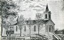
| Description: | Exterior view of a First Congregational Church. |

| Date: | 1854 |
|---|---|
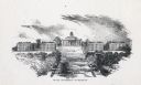
| Description: | Bird's-eye illustration of Milwaukee. |
| Date: | 1854 |
|---|---|
| Description: | View up Bascom Hill on the University of Wisconsin-Madison campus. |

| Date: | 1854 |
|---|---|
| Description: | Map of the whole state Wisconsin includes an inset of the vicinity of Milwaukee, which shows the boundaries for Lisbon, Menomonee, Pewaukee, Brookfield, Wa... |
If you didn't find the material you searched for, our Library Reference Staff can help.
Call our reference desk at 608-264-6535 or email us at:
