 Filter: Categories of Wisconsin Historical Images
Filter: FULL_DATE of 1851
Filter: Subject of railroads
Filter: Categories of Wisconsin Historical Images
Filter: FULL_DATE of 1851
Filter: Subject of railroads

| Date: | 1851 |
|---|---|
| Description: | Map of the Lake Superior region showing the railroad and steamboat connection. |
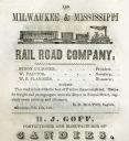
| Date: | 1851 |
|---|---|
| Description: | Advertisement for Milwaukee and Mississippi Railroad Company. There is an engraving of a train and a list of the officers of the company. |

| Date: | 1851 |
|---|---|
| Description: | Map exhaustively marks the townships, County Towns and villages of Wisconsin. It also shows rivers, canals, railroads, and plank roads. Each county's popul... |

| Date: | 1851 |
|---|---|
| Description: | Map outlines mid and southern Wisconsin county boundaries in blue, and city/town lines are provided. Other marks include mines, plank roads, and railroads. |

| Date: | 1851 |
|---|---|
| Description: | This map shows townships, villages, Indian villages, railroads, roads, mills, prairies, swamps, and canals. An inset map shows a plat of the copper distric... |
If you didn't find the material you searched for, our Library Reference Staff can help.
Call our reference desk at 608-264-6535 or email us at: