 Filter: Categories of Wisconsin Historical Images
Filter: FULL_DATE of 1851
Filter: Subject of land
Filter: Categories of Wisconsin Historical Images
Filter: FULL_DATE of 1851
Filter: Subject of land
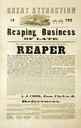
| Date: | 1851 |
|---|---|
| Description: | Advertising handbill for reapers designed by A.J. Cook and manufactured by Hatch and Whitely of Springfield in Clark County, Ohio. |

| Date: | 1851 |
|---|---|
| Description: | Plat map of the Town of Madison (Township 7N, Range 9E), from Volume 4, Federal Survey Plat Books. |

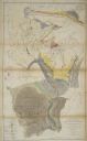
| Date: | 1851 |
|---|---|
| Description: | Map of the Lake Superior region showing the railroad and steamboat connection. |
| Date: | 1851 |
|---|---|
| Description: | Owen Geological Map of Wisconsin. |

| Date: | 1851 |
|---|---|
| Description: | Map exhaustively marks the townships, County Towns and villages of Wisconsin. It also shows rivers, canals, railroads, and plank roads. Each county's popul... |

| Date: | 1851 |
|---|---|
| Description: | Map of a portion of Merton including the Bark River, a mill, Fort Hill, and Indian mounds. |

| Date: | 1851 |
|---|---|
| Description: | Map outlines mid and southern Wisconsin county boundaries in blue, and city/town lines are provided. Other marks include mines, plank roads, and railroads. |

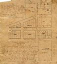
| Date: | 1851 |
|---|---|
| Description: | This manuscript map of the southern portion of the Town of Porterfield, Marinette County, Wisconsin, shows sections and land ownership. The Menominee River... |
| Date: | 1851 |
|---|---|
| Description: | Ink and pencil on paper. Shows plat of Delafield and local streets. Streets running left to right, top to bottom, are "Main Street 66 feet," "Wells Street ... |

| Date: | 1851 |
|---|---|
| Description: | This map shows plats with lots and block numbers of Madison. The far left corner features "University Ground" and some streets are labeled. Lake Monona is ... |

| Date: | 1851 |
|---|---|
| Description: | This map shows townships, villages, Indian villages, railroads, roads, mills, prairies, swamps, and canals. An inset map shows a plat of the copper distric... |
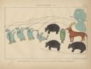
| Date: | 1851 |
|---|---|
| Description: | Pictograph E., Plate 63, "Kaizheosh, and his Band from Lake Vieu Desert. Michigan and Wisconsin." A group of symbols including birds, animals, a fish and a... |
If you didn't find the material you searched for, our Library Reference Staff can help.
Call our reference desk at 608-264-6535 or email us at: