 Filter: Categories of Wisconsin Historical Images
Filter: FULL_DATE of 1851
Filter: Subject of cities and towns
Filter: Subject of transportation
Filter: Categories of Wisconsin Historical Images
Filter: FULL_DATE of 1851
Filter: Subject of cities and towns
Filter: Subject of transportation

| Date: | 1851 |
|---|---|
| Description: | A rare photograph of U.S. Army soldiers stationed at Fort Howard rowing a boat on the Fox River. Fort Howard, built in 1816, was the first in the chain of ... |
| Date: | 1851 |
|---|---|
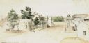
| Description: | A watercolor view of Madison. Prominent on the left side of King Street is the Madison Hotel. |

| Date: | 1851 |
|---|---|
| Description: | View of five soldiers rowing in a boat, beside a dock, with another soldier standing on the dock. The fort is in the background, complete with the fortifie... |

| Date: | 1851 |
|---|---|
| Description: | Several men rowing in a boat near Fort Howard that has an American Flag, barracks, and various related military buildings enclosed behind a wall. |

| Date: | 1851 |
|---|---|
| Description: | Map of the Lake Superior region showing the railroad and steamboat connection. |

| Date: | 1851 |
|---|---|
| Description: | Map exhaustively marks the townships, County Towns and villages of Wisconsin. It also shows rivers, canals, railroads, and plank roads. Each county's popul... |

| Date: | 1851 |
|---|---|
| Description: | Map outlines mid and southern Wisconsin county boundaries in blue, and city/town lines are provided. Other marks include mines, plank roads, and railroads. |
| Date: | 1851 |
|---|---|
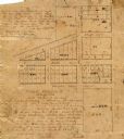
| Description: | Ink and pencil on paper. Shows plat of Delafield and local streets. Streets running left to right, top to bottom, are "Main Street 66 feet," "Wells Street ... |

| Date: | 1851 |
|---|---|
| Description: | This map shows plats with lots and block numbers of Madison. The far left corner features "University Ground" and some streets are labeled. Lake Monona is ... |

| Date: | 1851 |
|---|---|
| Description: | This map shows townships, villages, Indian villages, railroads, roads, mills, prairies, swamps, and canals. An inset map shows a plat of the copper distric... |
| Date: | 1851 |
|---|---|
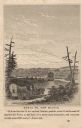
| Description: | Engraved view of a wagon train heading into Santa Fe, New Mexico. |
| Date: | 1851 |
|---|---|
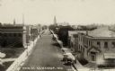
| Description: | Elevated view of a central street lined with businesses. Automobiles are parked at the curbs. There is a large building with columns on the left near an op... |

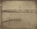
| Date: | 1851 |
|---|---|
| Description: | Elevated view across water towards Fort Howard. In the foreground is a man standing on a pier, and in the water nearby are five men rowing in a boat. Capti... |
| Date: | 1851 |
|---|---|
| Description: | A rare photograph of U.S. Army soldiers stationed at Fort Howard rowing a boat on the Fox River. Fort Howard, built in 1816, was the first in the chain of ... |
If you didn't find the material you searched for, our Library Reference Staff can help.
Call our reference desk at 608-264-6535 or email us at: