 Filter: Categories of Wisconsin Historical Images
Filter: FULL_DATE of 1850
Filter: Subject of transportation
Filter: County of Brown
Filter: Categories of Wisconsin Historical Images
Filter: FULL_DATE of 1850
Filter: Subject of transportation
Filter: County of Brown
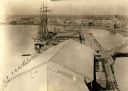
| Date: | 1850 |
|---|---|
| Description: | Elevated view of the Green Bay harbor and docks. |

| Date: | 1850 |
|---|---|
| Description: | This map shows the location of planned blocks and lot numbers, street names, and docks along the Fox River and canal. |

| Date: | 1850 |
|---|---|
| Description: | This photocopied map shows lot and block numbers, selected buildings, street names and state lock located on the Fox River. Includes a description of Deper... |
If you didn't find the material you searched for, our Library Reference Staff can help.
Call our reference desk at 608-264-6535 or email us at: