 Filter: Categories of Wisconsin Historical Images
Filter: FULL_DATE of 1846
Filter: Creator Name of Lapham, Increase Allen
Filter: Categories of Wisconsin Historical Images
Filter: FULL_DATE of 1846
Filter: Creator Name of Lapham, Increase Allen
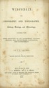
| Date: | 1846 |
|---|---|
| Description: | Title page of the book "Wisconsin: Geography and Topography". |

| Date: | 1846 |
|---|---|
| Description: | This map shows the counties and towns in existence at the time as well as lead and copper mines. |

| Date: | 1846 |
|---|---|
| Description: | This map shows lot and block numbers, roads, railroads, and some landowners’ names and includes the manuscript annotations: "From the Lapham collection" --... |

| Date: | 1846 |
|---|---|
| Description: | This map shows lot and block numbers, local streets, railroads, some landowners’ names, Milwaukee River, Menomonee River, and part of Lake Michigan. The ma... |
If you didn't find the material you searched for, our Library Reference Staff can help.
Call our reference desk at 608-264-6535 or email us at: