 Filter: Categories of Wisconsin Historical Images
Filter: FULL_DATE of 1845
Filter: Subject of human settlements
Filter: Subject of land
Filter: Year of 1800-1899
Filter: Categories of Wisconsin Historical Images
Filter: FULL_DATE of 1845
Filter: Subject of human settlements
Filter: Subject of land
Filter: Year of 1800-1899
| Date: | 1845 |
|---|---|
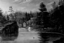
| Description: | View of the gorge at St. Croix with a boat and multiple figures visible in the background. |

| Date: | 1845 |
|---|---|
| Description: | Wisconsin was considered part of Michigan Territory until 1836, a year before Michigan entered statehood. Drawn three years before Wisconsin entered stateh... |
| Date: | 1845 |
|---|---|
| Description: | This manuscript map, drawn about 1845, shows the township and range grid, villages, post offices, and roads in Kenosha, Racine, and Walworth counties and i... |

| Date: | 1845 |
|---|---|
| Description: | This map shows lakes, rivers, Chippewa land, the U.S. Mineral Land Agency, boundary between U.S. and Canada, Methodist and Catholic missions, and American ... |
| Date: | 1845 |
|---|---|
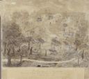
| Description: | Drawing of Shullsburg. Text at bottom reads: "Smelting lead ore in log furnaces. Scene in Gratiots Grove at Shullsburg, Wis. in 1845-6. Drawn from life. By... |

| Date: | 1845 |
|---|---|
| Description: | Map of Wisconsin, including lower western border with Iowa, southern border along Illinois, eastern shoreline of Lake Michigan, and northern area along Wis... |
If you didn't find the material you searched for, our Library Reference Staff can help.
Call our reference desk at 608-264-6535 or email us at: