 Filter: Categories of Wisconsin Historical Images
Filter: FULL_DATE of 1844
Filter: County of Milwaukee
Filter: Categories of Wisconsin Historical Images
Filter: FULL_DATE of 1844
Filter: County of Milwaukee
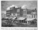
| Date: | 1844 |
|---|---|
| Description: | Illustration of the west side of East Water Street. |

| Date: | 1844 |
|---|---|
| Description: | An ink on paper, hand-drawn map of Milwaukee County that shows the sectioning of townships, the boundary of the canal grant, roads, streams, lakes, includi... |
If you didn't find the material you searched for, our Library Reference Staff can help.
Call our reference desk at 608-264-6535 or email us at: