 Filter: Categories of Wisconsin Historical Images
Filter: FULL_DATE of 1844
Filter: Creator Name of Owen, David Dale
Filter: Categories of Wisconsin Historical Images
Filter: FULL_DATE of 1844
Filter: Creator Name of Owen, David Dale
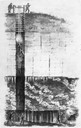
| Date: | 1844 |
|---|---|
| Description: | Cross section drawing of a Wisconsin lead mine. |

| Date: | 1844 |
|---|---|
| Description: | A hand-colored map and chart showing a geological cross-section from Rockingham, in present-day Scott County, Iowa, through Blue Mounds to the Wisconsin Ri... |
If you didn't find the material you searched for, our Library Reference Staff can help.
Call our reference desk at 608-264-6535 or email us at: