 Filter: Categories of Wisconsin Historical Images
Filter: FULL_DATE of 1839
Filter: Subject of work
Filter: Categories of Wisconsin Historical Images
Filter: FULL_DATE of 1839
Filter: Subject of work

| Date: | 1839 |
|---|---|
| Description: | This map, one of a series made by Thomas Jefferson Cram of the U.S. Topographical Engineers from personal surveys, covers the area from Green Bay to the ju... |
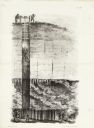
| Date: | 1839 |
|---|---|
| Description: | Cut-away lithography illustration of a mining operation, showing men lowering a miner into a mine where several other men are working. |
If you didn't find the material you searched for, our Library Reference Staff can help.
Call our reference desk at 608-264-6535 or email us at: