 Filter: Categories of Wisconsin Historical Images
Filter: FULL_DATE of 1838
Filter: Subject of roads
Filter: Categories of Wisconsin Historical Images
Filter: FULL_DATE of 1838
Filter: Subject of roads
| Date: | 1838 |
|---|---|
| Description: | This map of the Wisconsin Territory, accompanied by the photostat of an article from the January 13, 1838, Wisconsin democrat, shows the area described as ... |

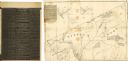
| Date: | 1838 |
|---|---|
| Description: | A map of the proposed route of the Milwaukee and Rock River Canal from Fort Atkinson on the Rock River in the west to the city of Milwaukee and Lake Michig... |

| Date: | 1838 |
|---|---|
| Description: | A color map of the settled part of Wisconsin Territory in 1838, including an inset map of the "Entire Territory of Wisconsin as Established by Act of Congr... |
If you didn't find the material you searched for, our Library Reference Staff can help.
Call our reference desk at 608-264-6535 or email us at: