 Filter: Categories of Wisconsin Historical Images
Filter: FULL_DATE of 1835
Filter: Subject of transportation
Filter: Categories of Wisconsin Historical Images
Filter: FULL_DATE of 1835
Filter: Subject of transportation
| Date: | 1835 |
|---|---|
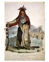
| Description: | Waa-Na-'Taa or The Foremost in Battle, Chief of the Sioux Tribe. Hand-colored lithograph from the Aboriginal Portfolio, painted at the Treaty of Prairie du... |

| Date: | 1835 |
|---|---|
| Description: | Little Lake Butte Des Morts just north of Lake Winnebago where Governor Lewis Cass of Michigan, and Thomas McKenney, head of the Bureau of Indian Affairs (... |

| Date: | 1835 |
|---|---|
| Description: | Map reads: "Map of the United States of America with its Territories and Districts - Including also a part of Upper and Lower Canada and Mexico". The map i... |

| Date: | 1835 |
|---|---|
| Description: | Two-story home with sloping roof. One man is whipping a team of eight cattle while another man drives the plow behind them. To the left stands a man near a... |

| Date: | 1835 |
|---|---|
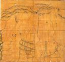
| Description: | Ink on tracing paper map of Green Bay, Wisconsin and nearby areas, Lake Winnebago, Fox and Wolf Rivers, and the junctions of the Mississippi and Wisconsin ... |

| Date: | 1835 |
|---|---|
| Description: | Plat for a proposed Sinsinawa City (never built), in Grant County, Wis. When it became clear in the mid-1830s that Wisconsin Territory would be established... |

| Date: | 1835 |
|---|---|
| Description: | These maps of the towns of Westport, Madison, and Blooming Grove, Dane County, Wisconsin, show sections, roads, trails, lakes and streams, and wetlands fro... |

| Date: | 1835 |
|---|---|
| Description: | Shows Walker’s Point, Juneau Town and Kilbourn Town, including labeled buildings, trails and Indian villages. Relief shown by hachures. Oriented with north... |
| Date: | 1835 |
|---|---|
| Description: | This map covers the Western Territory of the United States from the Rocky Mountains in Colorado south to Fort Smith, Arkansas, and from the Pacific Ocean e... |

| Date: | 1835 |
|---|---|
| Description: | An illustration of three men sitting at a table in a saloon on a steamboat. |

| Date: | 1835 |
|---|---|
| Description: | Map shows the Fox River, lot and block numbers, private claims, streets, a public squares, a manual labour school, and Fort Howard. An inset map shows a pl... |
If you didn't find the material you searched for, our Library Reference Staff can help.
Call our reference desk at 608-264-6535 or email us at: