 Filter: Categories of Wisconsin Historical Images
Filter: FULL_DATE of 1835
Filter: Subject of land
Filter: Categories of Wisconsin Historical Images
Filter: FULL_DATE of 1835
Filter: Subject of land
| Date: | 1835 |
|---|---|
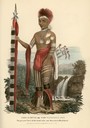
| Description: | Waa-Na-'Taa or The Foremost in Battle, Chief of the Sioux Tribe. Hand-colored lithograph from the Aboriginal Portfolio, painted at the Treaty of Prairie du... |

| Date: | 1835 |
|---|---|
| Description: | Little Lake Butte Des Morts just north of Lake Winnebago where Governor Lewis Cass of Michigan, and Thomas McKenney, head of the Bureau of Indian Affairs (... |
| Date: | 1835 |
|---|---|
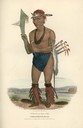
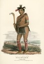
| Description: | Cut-taa-tas-tia, a celebrated Chief of the Fox Tribe. Hand-colored lithograph from the Aboriginal Portfolio, was drawn at the Treaty of Prairie du Chien (1... |
| Date: | 1835 |
|---|---|
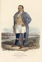
| Description: | Francis Godfroy, a celebrated Miami chief who was half French and half Miami. Hand-colored lithograph from the Aboriginal Portfolio, painted at the Treaty ... |
| Date: | 1835 |
|---|---|
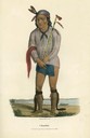
| Description: | Kee-o-kuck, or the Watching Fox, a Chief of the Sauk tribe and sucessor to Black Hawk. Hand-colored lithograph from the Aboriginal Portfolio, painted at th... |
| Date: | 1835 |
|---|---|
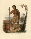
| Description: | Men-dow-min, or the Corn, a Chippewa (Ojibwa) dwarf. Hand-colored lithograph from the Aboriginal Portfolio, painted at the Treaty of Green Bay (1827). |
| Date: | 1835 |
|---|---|
| Description: | Nabu-naa-kee-shick, or the One Side of the Sky, a Chief of the Chippewa (Ojibwa) Tribe. Hand-colored lithograph from the Aboriginal Portfolio, painted at ... |
| Date: | 1835 |
|---|---|
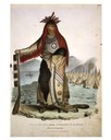
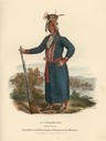
| Description: | O'-check-ka, or Four Legs, Head Chief of the Winnebago (Ho-Chunk) on Lake Michigan. Hand-colored lithograph from the Aboriginal Portfolio, painted at the ... |
| Date: | 1835 |
|---|---|
| Description: | A Sioux Chief. Hand-colored lithograph from the Aboriginal Portfolio, painted at the Treaty of Prairie du Chien (1825). He holds a pipe. |

| Date: | 1835 |
|---|---|
| Description: | Constructed for the Topographical Bureau [Wash.], 1835. Scale: 16 miles to 1 inch. Map of a portion of the Indian country lying east and west of the Missis... |

| Date: | 1835 |
|---|---|
| Description: | Map reads: "Map of the United States of America with its Territories and Districts - Including also a part of Upper and Lower Canada and Mexico". The map i... |

| Date: | 1835 |
|---|---|
| Description: | This map of Wisconsin Territory was compiled by public surveys in 1835; it is limited to modern-day southern Wisconsin. Included are two insets – one of th... |

| Date: | 1835 |
|---|---|
| Description: | Ink on tracing paper map of Green Bay, Wisconsin and nearby areas, Lake Winnebago, Fox and Wolf Rivers, and the junctions of the Mississippi and Wisconsin ... |

| Date: | 1835 |
|---|---|
| Description: | This hand-colored map shows the area from Michigan west to the Missouri River and Lake Winnipeg, and includes expedition routes of Stephen H. Long and Henr... |

| Date: | 1835 |
|---|---|
| Description: | Plat for a proposed Sinsinawa City (never built), in Grant County, Wis. When it became clear in the mid-1830s that Wisconsin Territory would be established... |

| Date: | 1835 |
|---|---|
| Description: | This manuscript map of Dane County, Wisconsin, from the first half of the 19th century shows the township and range grid, sections, cities and villages bot... |

| Date: | 1835 |
|---|---|
| Description: | These maps of the towns of Westport, Madison, and Blooming Grove, Dane County, Wisconsin, show sections, roads, trails, lakes and streams, and wetlands fro... |

| Date: | 1835 |
|---|---|
| Description: | This map is pen-and-ink on paper. The map shows landowners in "Milwalky" or present day Milwaukee. Includes "list of property offered to Mr. Walker". The m... |
If you didn't find the material you searched for, our Library Reference Staff can help.
Call our reference desk at 608-264-6535 or email us at: