 Filter: Categories of Wisconsin Historical Images
Filter: FULL_DATE of 1835
Filter: Subject of indians of north america
Filter: Categories of Wisconsin Historical Images
Filter: FULL_DATE of 1835
Filter: Subject of indians of north america
| Date: | 1835 |
|---|---|
| Description: | Waa-top-e-not, or the Eagle's Bed, a Chief of the Fox Tribe. Hand-colored lithograph from the Aboriginal Portfolio, painted at the Treaty of Prairie du Ch... |
| Date: | 1835 |
|---|---|
| Description: | Wadt-he-doo-kaana, a Chief of the Winnebago (Ho-Chunk) Tribe. Hand-colored lithograph from the Aboriginal Portfolio, painted at the Treaty of Prairie du C... |
| Date: | 1835 |
|---|---|
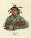
| Description: | Waa-kaun-see-kaa, the Rattle-Snake, a Chief of the Winnebago (Ho-Chunk) Tribe. Hand-colored lithograph from the Aboriginal Portfolio, painted at the Treat... |

| Date: | 1835 |
|---|---|
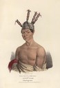
| Description: | Waa-bin-de-ba, or the White Headed Eagle, a Chippeway (Ojibwa) Chief. Hand-colored lithograph from the Aboriginal Portfolio. |

| Date: | 1835 |
|---|---|
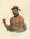
| Description: | Wa-em-boesh-kaa, a Chippeway (Ojibwa) Chief. Hand-colored lithograph from the Aboriginal Portfolio, painted at the Treaty of Fond du Lac (1826). He is smok... |
| Date: | 1835 |
|---|---|
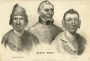
| Description: | Portrait of Black Hawk, Sauk Chief (center); Wabokieshiek, the Winnebago (Ho-Chunk) Prophet (left); Black Hawk's son (right). Lithograph from the Aborigina... |
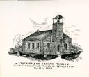
| Date: | 1835 |
|---|---|
| Description: | Drawing of the Stockbridge Indian Mission, built in about 1834. |
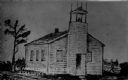
| Date: | 1835 |
|---|---|
| Description: | Drawing of the Stockbridge Indian mission. |

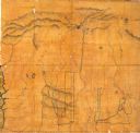
| Date: | 1835 |
|---|---|
| Description: | Constructed for the Topographical Bureau [Wash.], 1835. Scale: 16 miles to 1 inch. Map of a portion of the Indian country lying east and west of the Missis... |

| Date: | 1835 |
|---|---|
| Description: | Shows Walker’s Point, Juneau Town and Kilbourn Town, including labeled buildings, trails and Indian villages. Relief shown by hachures. Oriented with north... |
| Date: | 1835 |
|---|---|
| Description: | This map covers the Western Territory of the United States from the Rocky Mountains in Colorado south to Fort Smith, Arkansas, and from the Pacific Ocean e... |
If you didn't find the material you searched for, our Library Reference Staff can help.
Call our reference desk at 608-264-6535 or email us at: