 Filter: Categories of Wisconsin Historical Images
Filter: FULL_DATE of 1832
Filter: Creator Name of Unknown
Filter: Subject of water
Filter: Categories of Wisconsin Historical Images
Filter: FULL_DATE of 1832
Filter: Creator Name of Unknown
Filter: Subject of water
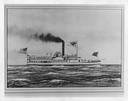
| Date: | 1832 |
|---|---|
| Description: | An early type of sidewheel passenger and freight steamboat The Milwaukie, also known as The Milwaukee. It was used on Lake Erie and upper lak... |

| Date: | 1832 |
|---|---|
| Description: | Route of Military Road from Fort Crawford to Fort Howard. Map shows beginning of route at Fort Crawford. |

| Date: | 1832 |
|---|---|
| Description: | This map shows lot and block numbers, as well as the location of a shot tower, houses, stores, and barns. The map is oriented with the north to the left. T... |
If you didn't find the material you searched for, our Library Reference Staff can help.
Call our reference desk at 608-264-6535 or email us at: