 Filter: Categories of Wisconsin Historical Images
Filter: FORMAT_TYPE of prints, photomechanical
Filter: Year of 2000-Present
Filter: Subject of service industries
Filter: Categories of Wisconsin Historical Images
Filter: FORMAT_TYPE of prints, photomechanical
Filter: Year of 2000-Present
Filter: Subject of service industries

| Date: | 2003 |
|---|---|
| Description: | The front of map shows trails throughout the bottom half of Wisconsin and includes text on snowmobile rules and tourism contacts. The reverse shows trails ... |
| Date: | 2007 |
|---|---|
| Description: | The front of map shows trails throughout the bottom half of Wisconsin and includes text on snowmobile rules and tourism contacts. The reverse shows trails ... |

| Date: | 2006 |
|---|---|
| Description: | This map includes indexed advertisements and map of the Lac du Flambeau region on back. The map is broken into 9 zones, each marked with state and club tra... |
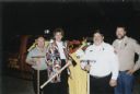
| Date: | 10 31 2001 |
|---|---|
| Description: | Group portrait with accompanying caption: "Pictured from left to right are recently retired Rock Springs Fire Department chief James "Bink" Mooney, 50th As... |

| Date: | 2008 |
|---|---|
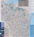
| Description: | This double sided map shows roads, railroads, biking trails, civil townships, parks, wildlife refuges, town halls, and hospitals. The region map covers par... |
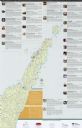
| Date: | 2012 |
|---|---|
| Description: | This map includes a descriptive index of galleries and studios with color illustrations, on both sides. |

| Date: | 2004 |
|---|---|
| Description: | This map shows ATMs, houses of worship, hotels, parking ramps, public parking, union cab stands, bus stops, business district, parks and public areas, gove... |
If you didn't find the material you searched for, our Library Reference Staff can help.
Call our reference desk at 608-264-6535 or email us at: