 Filter: Categories of Wisconsin Historical Images
Filter: FORMAT_TYPE of prints, photomechanical
Filter: Year of 2000-Present
Filter: Subject of recreation
Filter: Categories of Wisconsin Historical Images
Filter: FORMAT_TYPE of prints, photomechanical
Filter: Year of 2000-Present
Filter: Subject of recreation

| Date: | 2006 |
|---|---|
| Description: | This map includes indexed advertisements and map of the Lac du Flambeau region on back. The map is broken into 9 zones, each marked with state and club tra... |

| Date: | 2008 |
|---|---|
| Description: | This double sided map shows roads, railroads, biking trails, civil townships, parks, wildlife refuges, town halls, and hospitals. The region map covers par... |

| Date: | 2000 |
|---|---|
| Description: | This map shows national parks, county and state forests, Indian reservations, municipal land, private land, docks, boat access, camping, and points of inte... |

| Date: | 2000 |
|---|---|
| Description: | This map shows Wisconsin Public Service Corporation property, special regulation areas, public boat landings, roads, parks, and other recreation areas. Ins... |

| Date: | 2005 |
|---|---|
| Description: | This map shows dams and falls, areas of portage, canoe and kayak access, boat launches, parking, restrooms, picnic areas, dining, rapid water, parks, and b... |
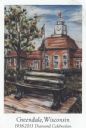
| Date: | 2013 |
|---|---|
| Description: | Color postcard of an illustration called "Time and Place" by Jason Van Roo. Caption reads: "Greendale, Wisconsin 1938-2013 Diamond Celebration, Wis." Text... |

| Date: | 10 15 2020 |
|---|---|
| Description: | Proclamation for Blue Flame Day on October 23, 2020. Signed by Tony Evers, Governor, and Douglas La Follete, Secretary of State. |
If you didn't find the material you searched for, our Library Reference Staff can help.
Call our reference desk at 608-264-6535 or email us at: