 Filter: Categories of Wisconsin Historical Images
Filter: FORMAT_TYPE of prints, photomechanical
Filter: Year of 2000-Present
Filter: County of Milwaukee
Filter: Categories of Wisconsin Historical Images
Filter: FORMAT_TYPE of prints, photomechanical
Filter: Year of 2000-Present
Filter: County of Milwaukee

| Date: | 2000 |
|---|---|
| Description: | This map shows the industrial area along the Menominee River and canals. Industrial buildings are shown in orange and labeled in red. Other areas are shown... |

| Date: | 2005 |
|---|---|
| Description: | This map shows dams and falls, areas of portage, canoe and kayak access, boat launches, parking, restrooms, picnic areas, dining, rapid water, parks, and b... |
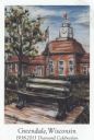
| Date: | 2013 |
|---|---|
| Description: | Color postcard of an illustration called "Time and Place" by Jason Van Roo. Caption reads: "Greendale, Wisconsin 1938-2013 Diamond Celebration, Wis." Text... |
If you didn't find the material you searched for, our Library Reference Staff can help.
Call our reference desk at 608-264-6535 or email us at: