 Filter: Categories of Wisconsin Historical Images
Filter: FORMAT_TYPE of prints, photomechanical
Filter: Year of 1900-1999
Filter: County of Kewaunee
Filter: Categories of Wisconsin Historical Images
Filter: FORMAT_TYPE of prints, photomechanical
Filter: Year of 1900-1999
Filter: County of Kewaunee
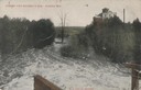
| Date: | 1905 |
|---|---|
| Description: | View from dam looking down river. A large building is in the background. Caption reads: "Looking Over Brummer's Dam, Algoma, Wis." |
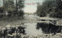
| Date: | 1905 |
|---|---|
| Description: | View of pond with rocky shoreline. Caption reads: "Scene on Bruemmer's Pond, Algoma, Wis.". |
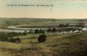
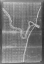
| Date: | 1909 |
|---|---|
| Description: | Caption reads: "Ox Bow on the Kewaunee River near Kewaunee, Wis." |
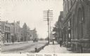
| Date: | 09 20 1922 |
|---|---|
| Description: | Photographic postcard of the business district. Sidewalk view shows pedestrians and a vehicle in the street. Telephone poles and small horsehead shaped hit... |
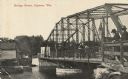
| Date: | 07 19 1920 |
|---|---|
| Description: | Photographic postcard shoreline view of a bridge. Two men in hats are standing on the far right at a railing on the truss bridge looking toward the opposit... |
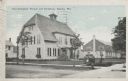
| Date: | 10 07 1930 |
|---|---|
| Description: | Colorized postcard view of the exterior and lawns of the Door-Kewaunee Normal School and its dormitory. Street view of the school with a few small trees l... |

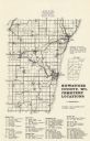
| Date: | 1946 |
|---|---|
| Description: | Map of Kewaunee County, Wisconsin, shows towns, cities and villages, roads and highways, railroads, schools, lighthouses, place names, town divisions, comm... |

| Date: | 1970 |
|---|---|
| Description: | A map of parks of Kewaunee County, Wisconsin, showing the fishing spots, lakes and parks in the area, it also provides a location map of the area. On the ... |
| Date: | 1977 |
|---|---|
| Description: | A map of Kewaunee County, Wisconsin that identifies the locations of 46 cemeteries in the county. The cemeteries are listed by town. |

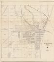
| Date: | 1961 |
|---|---|
| Description: | This map shows streets and some points of interest. Kewaunee River and Lake Michigan are both labeled. |
| Date: | 1930 |
|---|---|
| Description: | This cadastral map shows ownership and acreage of lots. Streets, the Kewaunee River, and Lake Michigan are labeled. |

| Date: | 1926 |
|---|---|
| Description: | This blueprint manuscript map shows buildings, railroads, and United States property. Water depths shown by soundings, tints, and isolines. |

| Date: | 1937 |
|---|---|
| Description: | This is map 1 from a set of 4 taken from an atlas. The map shows streets, neighborhoods and proposed subdivision. Lake Michigan, Algoma Outer Harbor, the A... |
| Date: | 1937 |
|---|---|
| Description: | This is map 2 from a set of 4 taken from an atlas. The map shows streets, railroad tracks, and plots. The back of the map includes an index of residents of... |

| Date: | 1937 |
|---|---|
| Description: | This is map 3 from a set of 4 taken from an atlas. The map shows streets, neighborhoods, lots, and railroad tracks. Lake Michigan, the Kewaunee River, and ... |

| Date: | 1937 |
|---|---|
| Description: | This is map 4 from a set of 4 taken from an atlas. The map includes a legend in the lower left corner of roads, trails, county lines, town lines, section l... |

| Date: | 1955 |
|---|---|
| Description: | This map shows roads, trails, county lines, town borders, section lines, railroads, rivers, lakes, and Lake Michigan on the far right. The bottom margin in... |
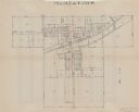
| Date: | 1900 |
|---|---|
| Description: | This photocopy map shows land parcels, block numbers, streets, the Kewaunee River, and Lake Michigan on the far right side. The original map was created ar... |
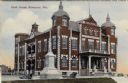
| Date: | 1908 |
|---|---|
| Description: | Colorized postcard view of the Kauwaunee County Courthouse and adjoining veterans' memorial. The monument is flanked by cannons. Caption reads: "Court Hous... |
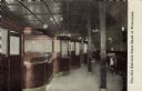
| Date: | 1915 |
|---|---|
| Description: | View of the interior of a bank, with a row of teller cages on the left, and columns on the right. The president's office is on the far left. Caption reads:... |
If you didn't find the material you searched for, our Library Reference Staff can help.
Call our reference desk at 608-264-6535 or email us at: