 Filter: Categories of Wisconsin Historical Images
Filter: FORMAT_TYPE of prints, photomechanical
Filter: Year of 1900-1999
Filter: County of Iron
Filter: Categories of Wisconsin Historical Images
Filter: FORMAT_TYPE of prints, photomechanical
Filter: Year of 1900-1999
Filter: County of Iron
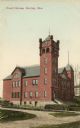
| Date: | 1905 |
|---|---|
| Description: | View across road toward the court house. Caption reads: "Court House, Hurley, Wis." |

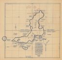
| Date: | 1922 |
|---|---|
| Description: | A map of Iron County, Wisconsin, shows sections and the towns of Upson, Hurley, Hamilton, Saxon, and Mercer, lakes and streams, villages, railroads, roads ... |

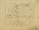
| Date: | 1932 |
|---|---|
| Description: | A map of Iron County, Wisconsin, shows towns and sections, lakes and streams, villages, railroads, roads, and La Point and Lac Du Flambeau Indian reservati... |

| Date: | 1925 |
|---|---|
| Description: | Shows buildings, piers, winter and summer levels, and resort lands. Depths shown by isolines. Relief shown by contours. From the E.P. Sherry papers relatin... |

| Date: | 1937 |
|---|---|
| Description: | "Prepared ... March 1937." Includes location map. "State of Wisconsin, Conservation Department, Map Division"--upper left. From the E.P. Sherry papers rela... |
| Date: | 1935 |
|---|---|
| Description: | This map shows property owners, government lots, and roads around Pine Lake in Rusk and Chippewa Counties. Also shows Silver and McDonald Lakes. "This map ... |

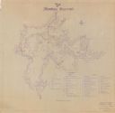
| Date: | 1934 |
|---|---|
| Description: | This 1934 zoning map of Iron County, Wisconsin, shows the township and range grid, towns, sections, roads, and lakes and streams. Forestry and recreation d... |

| Date: | 11 1905 |
|---|---|
| Description: | Sanborn map of Hurley including mining features. |

| Date: | 1941 |
|---|---|
| Description: | This is map one of three maps that show trails, roads and fire lanes, utilities, resorts, submerged lakes, vegetation, flowage right lands, and timber righ... |
| Date: | 1938 |
|---|---|
| Description: | This map shows lakes, lodges and resorts, roads, and railroads in Sherman township and a portion of Mercer township. Points of interest are marked with a s... |

| Date: | 1909 |
|---|---|
| Description: | This map covers Iron and Price Counties and portions of Sawyer and Oneida Counties. The map shows vacant and sold Wis. Central Ry. land, settlers houses, s... |
| Date: | 1941 |
|---|---|
| Description: | This is map two of a set of three and shows boundaries and flowage right lands in red ink. A legend in the lower right corner includes a legend of symbols ... |

| Date: | 1941 |
|---|---|
| Description: | This is map three of a set of three, and shows trails, roads and fire lanes, utilities, resorts, submerged lakes, vegetation, flowage right lands, and timb... |

| Date: | 1930 |
|---|---|
| Description: | This map shows schools, school districts, town sections, highways, railroads, and hydrography of the area around Hurley. The right margin includes and expl... |
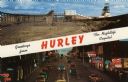
| Date: | 1959 |
|---|---|
| Description: | Two views of Hurley. At the top is the Cary Mine. On the bottom is Silver Street lined with clubs and electric signs. Caption reads: "Greetings from Hurley... |

| Date: | 1912 |
|---|---|
| Description: | View from water towards a shoreline and a log cabin in the woods by a lake. Rowboats and a small pier are at the shoreline. Caption reads: "The Oasis, Merc... |
If you didn't find the material you searched for, our Library Reference Staff can help.
Call our reference desk at 608-264-6535 or email us at: