Filter: Categories of Wisconsin Historical Images
Filter: FORMAT_TYPE of prints, photomechanical
Filter: Year of 1800-1899
Filter: Year of 1840-1849
Filter: Categories of Wisconsin Historical Images
Filter: FORMAT_TYPE of prints, photomechanical
Filter: Year of 1800-1899
Filter: Year of 1840-1849

| Date: | 04 19 1849 |
|---|---|
| Description: | Poster offering $600 reward for the return of three runaway slaves in Calvert County, Maryland. The three slaves are Henry Morsell, Jim Parker, and Bill Hu... |
| Date: | 1846 |
|---|---|
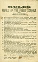
| Description: | "Rules to be observed by the pupils of public schools of Milwaukee." |
| Date: | 1849 |
|---|---|
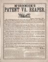
| Description: | Advertising handbill for Cyrus Hall McCormick's patent Virginia Reaper. Printed for C.H. McCormick & Co. by James J. Langdon, Chicago, Illinois. |
| Date: | 1844 |
|---|---|
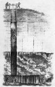
| Description: | Cross section drawing of a Wisconsin lead mine. |
| Date: | 1844 |
|---|---|
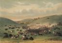
| Description: | Indians on horseback hunting buffaloes (Plate 9). "Some sixty or seventy young men, all mounted on their wild horses, and armed with bows and lances only... |
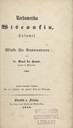
| Date: | 1848 |
|---|---|
| Description: | Title page for the book "Nord-Amerika, Wisconsin, Calumet," by Dr. Carl de Haas. |

| Date: | 1848 |
|---|---|
| Description: | Foldout map of a sketch of the town grid of Calumet. |
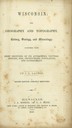
| Date: | 1846 |
|---|---|
| Description: | Title page of the book "Wisconsin: Geography and Topography". |

| Date: | 1844 |
|---|---|
| Description: | Map of Wisconsin including Lakes Michigan and Superior. Inset includes "N.W. Part of Wiskonsan." |
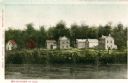
| Date: | 1842 |
|---|---|
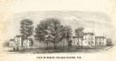
| Description: | View across the river towards several residences on the opposite shoreline. Caption reads: "Watertown in 1842." |

| Date: | 1847 |
|---|---|
| Description: | An artists rendition of the western view of the Thiensville mills from the local tavern. Caption reads: "West View of Thiensville Mills from the Tavern." |

| Date: | 1848 |
|---|---|
| Description: | Immigrant map. |

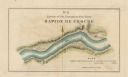
| Date: | 1840 |
|---|---|
| Description: | This map surveyed under the direction of Captain Thomas J. Cram is one in a series of seventeen that accompanied Cram's report on the Fox-Wisconsin river s... |

| Date: | 1840 |
|---|---|
| Description: | This map surveyed under the direction of Captain Thomas J. Cram is one in a series of seventeen that accompanied Cram's report on the Fox-Wisconsin river s... |
| Date: | 1840 |
|---|---|
| Description: | This map surveyed under the direction of Captain Thomas J. Cram is one in a series of seventeen that accompanied Cram's report on the Fox-Wisconsin river s... |
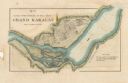
| Date: | 1840 |
|---|---|
| Description: | This map surveyed under the direction of Captain Thomas J. Cram is one in a series of seventeen that accompanied Cram's report on the Fox-Wisconsin river s... |

| Date: | 1840 |
|---|---|
| Description: | This map surveyed under the direction of Captain Thomas J. Cram is one in a series of seventeen that accompanied Cram's report on the Fox-Wisconsin river s... |

| Date: | 1840 |
|---|---|
| Description: | This map surveyed under the direction of Captain Thomas J. Cram is one in a series of seventeen that accompanied Cram's report on the Fox-Wisconsin river s... |
If you didn't find the material you searched for, our Library Reference Staff can help.
Call our reference desk at 608-264-6535 or email us at: