 Filter: Categories of Wisconsin Historical Images
Filter: FORMAT_TYPE of prints, photomechanical
Filter: Year of 1800-1899
Filter: Year of 1810-1819
Filter: Categories of Wisconsin Historical Images
Filter: FORMAT_TYPE of prints, photomechanical
Filter: Year of 1800-1899
Filter: Year of 1810-1819

| Date: | 1814 |
|---|---|
| Description: | Map of the Upper Territories of the United States. |

| Date: | 1813 |
|---|---|
| Description: | Eastern half of the United States. Scale: 2.5 inches = 250 miles. |

| Date: | 1814 |
|---|---|
| Description: | Scale: about 43 miles to 1 in. Boundaries colored. |
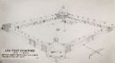
| Date: | 1817 |
|---|---|
| Description: | Sketch of an elevated view of Fort Crawford (1816-1829). |

| Date: | 10 08 1811 |
|---|---|
| Description: | A handbill entitled "McKinley, The Poltroon & Assassin, In His True Colors." |

| Date: | 1816 |
|---|---|
| Description: | This is a photostat copy of a manuscript map in the National Archives showing a plan of Fort Howard and a view of its north side. Originally surveyed by Wi... |
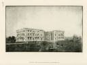
| Date: | 1814 |
|---|---|
| Description: | Exterior view of the U.S. Capitol building after the fire in August. The Federal building was burned by British forces during the War of 1812. In the foreg... |
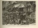
| Date: | 1814 |
|---|---|
| Description: | Etching depicting the burning of Washington, D.C. by the British during the War of 1812. In the foreground are a number of soldiers moving toward the Capit... |
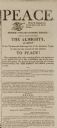
| Date: | 02 13 1815 |
|---|---|
| Description: | Newspaper article declaring peace between the United States and Great Britain at the end of the War of 1812. |

| Date: | 1810 |
|---|---|
| Description: | This map shows lot and block numbers, streets, and the public square. The bottom right margin reads: "Robert M. Eberts, Henry S. Baird, A.G. Ellis, R.S. Sa... |
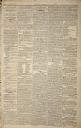
| Date: | 09 20 1814 |
|---|---|
| Description: | Page one of "Baltimore Patriot and Evening Advertiser." |

| Date: | 1814 |
|---|---|
| Description: | A map of the Harbour (sic) of St. Catherine (Brazil). |
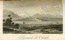
| Date: | 1816 |
|---|---|
| Description: | The four-stepped, low-rising Pyramid of Cholula, covered in sparse vegetation, stands in a flat valley, surrounded by distant mountains. A stairway leads u... |
If you didn't find the material you searched for, our Library Reference Staff can help.
Call our reference desk at 608-264-6535 or email us at: