Filter: Categories of Wisconsin Historical Images
Filter: FORMAT_TYPE of prints, photomechanical
Filter: Year of 1800-1899
Filter: Categories of Wisconsin Historical Images
Filter: FORMAT_TYPE of prints, photomechanical
Filter: Year of 1800-1899

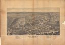
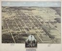
| Date: | 1881 |
|---|---|
| Description: | Darlington's first settlers arrived by 1826, attracted by the lead mines of the area. Arrival of the railroad in 1856 stimulated growth, and in 1857 the co... |

| Date: | 1896 |
|---|---|
| Description: | Bird's-eye map of Darlington. Area bordered by Washington and North Streets, upper left hand corner, the fairgrounds, upper right corner, River Street, bot... |
| Date: | 1875 |
|---|---|
| Description: | Bird's-eye map of Dodgeville, looking east, with insets of the high school and county courthouse. |

| Date: | 1872 |
|---|---|
| Description: | Birds-eye drawing of Eau Claire depicts street names and street locations, houses, trees, bridges, piers, canals, railroads, and the Chippewa and Eau Clair... |
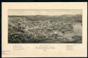
| Date: | 1881 |
|---|---|
| Description: | The county and city of Florence were named for Florence Hulst, the wife of an early settler. This view illustrates the two industries, mining and lumbering... |

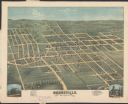
| Date: | 1893 |
|---|---|
| Description: | This photocopy of a bird’s-eye-view map shows illustrated houses and various buildings. Streets and the Rock River are labeled. An index to points of inter... |

| Date: | 1874 |
|---|---|
| Description: | Bird's-eye map of Grand Rapids. |

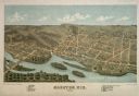
| Date: | 1879 |
|---|---|
| Description: | Bird's-eye map of Hartford. |

| Date: | 1877 |
|---|---|
| Description: | Bird's-eye map of Janesville on the Rock River. |

| Date: | 1878 |
|---|---|
| Description: | Bird's-eye map of Kewaskum. Includes a list of hotels, churches, post office, railroad depot, etc. |

| Date: | 1870 |
|---|---|
| Description: | Bird's-eye map of Kilbourn City, now known as Wisconsin Dells. Kilbourn City was platted in the 1850s and received a boost when the La Crosse and Milwaukee... |
| Date: | 1875 |
|---|---|
| Description: | Bird's-eye map of Lancaster, with inset of Monument for the Soldiers of Grant County. |

| Date: | 1870 |
|---|---|
| Description: | Bird's-eye map of Madison. The Lakeside House resort is in the foreground, which burned in 1877, in what is now Olin Park. |
If you didn't find the material you searched for, our Library Reference Staff can help.
Call our reference desk at 608-264-6535 or email us at: