 Filter: Categories of Wisconsin Historical Images
Filter: FORMAT_TYPE of prints, photomechanical
Filter: Year of 1800-1899
Filter: County of La Crosse
Filter: Categories of Wisconsin Historical Images
Filter: FORMAT_TYPE of prints, photomechanical
Filter: Year of 1800-1899
Filter: County of La Crosse

| Date: | 1867 |
|---|---|
| Description: | Bird's-eye map of La Crosse with nine insets of residences, schools, and the Court House and Jail. |

| Date: | 1887 |
|---|---|
| Description: | Bird's-eye map of La Crosse, with six insets including residences, a store front, The John Gund Brewing Company, and C. & J. Michel Brewing Company. |
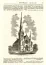
| Date: | 06 26 1869 |
|---|---|
| Description: | An engraving from the Billed-Magazine of the First Congregational Church. |
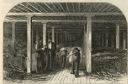
| Date: | 1877 |
|---|---|
| Description: | Etching of interior of bonded warehouse with four men present, two conversing and two rolling barrels. |
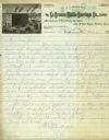
| Date: | 1887 |
|---|---|
| Description: | Letterhead of the La Crosse Wallis Carriage Co., manufacturers of fine family carriages, showing a view of the factory with the Mississippi River in the ba... |
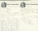
| Date: | 1889 |
|---|---|
| Description: | Letterhead stationery of the La Crosse National Bank, with an engraved image of the bank building at the top. |

| Date: | 1873 |
|---|---|
| Description: | A map that covers parts of Winona and Houston Counties, Minnesota and La Crosse County, Wisconsin, showing the proposed railroad routes, constructed rail l... |

| Date: | 1890 |
|---|---|
| Description: | This manuscript map of Township 16 North, Range 6 West, 4th Principal Meridian, encompasses the Town of Barre and the southern portion of the Town of Hamil... |

| Date: | 1890 |
|---|---|
| Description: | This late 19th century map shows sections, state lands, Barre Center P.O. (now Barre Mills), railroads, topography, and streams and wetlands in the Town of... |

| Date: | 1857 |
|---|---|
| Description: | Map of La Crosse County, Wisconsin showing village plat, farm houses, schools, roads, railroads, township names (New Amsterdam, Dacota, Minnesota, Driesbac... |

| Date: | 1874 |
|---|---|
| Description: | Map shows townships and sections, landownership and acreages, railroads, and roads. The map was compiled by the civil engineer and city surveyor agent H.I.... |

| Date: | 1870 |
|---|---|
| Description: | This map of the Village of North La Crosse is partially hand-drawn and includes text about the land in the lower margin. |

| Date: | 1874 |
|---|---|
| Description: | This map of La Crosse is accompanied by other plats of subdivision of the city. The relief is shown by hachures. The additions include: Rudolf Gripps Addit... |

| Date: | 1880 |
|---|---|
| Description: | This map of La Crosse shows the Chicago, Milwaukee and St. Paul Railroad, the Southern Minnesota Railroad and the Chicago, Dubuque and Minnesota Railroad, ... |

| Date: | 1891 |
|---|---|
| Description: | This map of La Crosse shows eighteen city wards in red, railroads, cemeteries, fair grounds, labeled streets, islands, and the Mississippi River. The left ... |

| Date: | 1893 |
|---|---|
| Description: | This map of La Crosse shows city ward boundaries in red, streets, railroads, cemeteries, Grand station crossing, the road to French Island, depots, Lake Pa... |

| Date: | 1893 |
|---|---|
| Description: | This map of La Crosse shows wards 1-20, streets, railroads, the Inter State Fair Grounds, islands, and the Mississippi River. Relief is shown by hachures. ... |

| Date: | 1800 |
|---|---|
| Description: | This map of the Village of North La Crosse was likely published before 1871 and shows street names, additions, section and lot numbers, railroads (specific... |

| Date: | 1857 |
|---|---|
| Description: | This map show city plats including the name and number of the plats as well as some land ownership. Some of the plats have manuscript annotations outlined ... |
If you didn't find the material you searched for, our Library Reference Staff can help.
Call our reference desk at 608-264-6535 or email us at:
