 Filter: Categories of Wisconsin Historical Images
Filter: FORMAT_TYPE of prints, photomechanical
Filter: Subject of water skiing
Filter: Categories of Wisconsin Historical Images
Filter: FORMAT_TYPE of prints, photomechanical
Filter: Subject of water skiing

| Date: | 1962 |
|---|---|
| Description: | This map shows roads, golf courses, ski areas, boat landings, camp sites, waysides, parks, beaches, scenic views, virgin timber tracts, airports, boys and ... |

| Date: | 1969 |
|---|---|
| Description: | This map shows ski areas, resorts, camps, special areas, airports, and roads. The map covers Vilas and Oneida counties and parts of Iron, Price, Lincoln, L... |

| Date: | 1962 |
|---|---|
| Description: | This colored map represents "Tour #1" of a series of driving tours of the state published by the Sperry & Hutchinson Company, in order to "help you enjoy W... |

| Date: | |
|---|---|
| Description: | The non-mailing side of a wrap-around postcard cover. Glued inside is a folded series of two sided scenes of attractions in Central Wisconsin. Across the i... |

| Date: | 1959 |
|---|---|
| Description: | Elevated view from hill of a waterskier and motorboat on Rock Lake. |
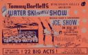
| Date: | 1963 |
|---|---|
| Description: | "Giant post card" advertising Tommy Bartlett's Water Ski Thrill Show on Lake Delton in the Wisconsin Dells, and Dancing Waters, direct from Radio City Musi... |

| Date: | 1957 |
|---|---|
| Description: | Text on front reads: "Two Rivers - The Coolest Spot in Wis." On reverse: "A speed boat, blue waters and a pair of water skis make a perfect day. Vacationla... |
If you didn't find the material you searched for, our Library Reference Staff can help.
Call our reference desk at 608-264-6535 or email us at: