 Filter: Categories of Wisconsin Historical Images
Filter: FORMAT_TYPE of prints, photomechanical
Filter: Subject of water
Filter: Categories of Wisconsin Historical Images
Filter: FORMAT_TYPE of prints, photomechanical
Filter: Subject of water

| Date: | 1856 |
|---|---|
| Description: | View looking west from Lake Michigan with several steam ships and sailing vessels in harbor. There is a lighthouse to left of center, along shoreline. |

| Date: | 1890 |
|---|---|
| Description: | Bird's-eye map of Ashland, viewed from Lake Superior, with insets of Prentice Park and Fishery. Population 16,000. Increase in Ten Years, 11,000. |

| Date: | 1930 |
|---|---|
| Description: | Page 8 of the 1930 schedule is a map of the routes of the Goodrich Steamship Lines in Lake Michigan and Lake Huron. |
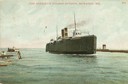
| Date: | |
|---|---|
| Description: | The screw rail ferry, Pere Marquette 18, entering the harbor. Caption reads: "Pere Marquette Steamer Entering, Milwaukee, Wis." |
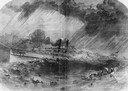
| Date: | 09 22 1860 |
|---|---|
| Description: | Sketch from the "New York Illustrated News" of the sinking of the sidewheel passenger, Lady Elgin. She was struck and sunk by the Augusta on ... |
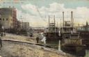
| Date: | 1900 |
|---|---|
| Description: | Riverboats tied at the levee in La Crosse with the Gypsy in the foreground. Caption reads: "The Levee, La Crosse, Wis." |
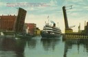
| Date: | |
|---|---|
| Description: | Colorized view depicting the passenger excursion vessel, "Christopher Columbus," approaching the East Water Street Bridge. Caption reads: "Whaleback Steame... |

| Date: | 1861 |
|---|---|
| Description: | Drawn the first year of the Civil War, this colored 1861 map of Dane County shows its towns, cities and lakes. It includes insets of the wards of Madison a... |

| Date: | 1931 |
|---|---|
| Description: | Describes the amenities aboard the "North American" and "South American". |
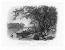
| Date: | 1832 |
|---|---|
| Description: | Travellers setting up camp along the Missouri River. |
| Date: | 1832 |
|---|---|
| Description: | Mih-Tutta-Hangkusch, a Mandan village with boats on the river in foreground. |

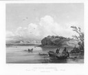
| Date: | 1832 |
|---|---|
| Description: | Junction of the Yellowstone River and the Missouri River. |

| Date: | 1891 |
|---|---|
| Description: | Bird's-eye map of Wausau, looking north with ninety-eight businesses, industries, churches, schools, and civic buildings identified in location key below i... |
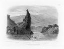
| Date: | 1832 |
|---|---|
| Description: | The Citadel Rock on the Upper Missouri River. |
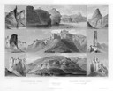
| Date: | 1832 |
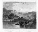
|---|---|
| Description: | Remarkable hills on the Upper Missouri River (views 1-9). Various landscapes and rock formations. |
| Date: | 1832 |
|---|---|
| Description: | Herds of bison and elk on the Upper Missouri River. |

| Date: | 1853 |
|---|---|
| Description: | Bird's-eye map of Milwaukee looking east toward Lake Michigan from a bluff, long since graded into a slope, at about 6th Street between Wisconsin Avenue an... |

| Date: | 1885 |
|---|---|
| Description: | Bird's-eye view of Watertown with indexed points of interest. |
If you didn't find the material you searched for, our Library Reference Staff can help.
Call our reference desk at 608-264-6535 or email us at:

