 Filter: Categories of Wisconsin Historical Images
Filter: FORMAT_TYPE of prints, photomechanical
Filter: Subject of water
Filter: Subject of rivers
Filter: Categories of Wisconsin Historical Images
Filter: FORMAT_TYPE of prints, photomechanical
Filter: Subject of water
Filter: Subject of rivers
| Date: | 11 25 1871 |
|---|---|
| Description: | Engraved view of Peshtigo Fire showing people trying to escape the flames by boat and on horseback. A team of cattle also seek refuge and several birds tak... |

| Date: | 09 1871 |
|---|---|
| Description: | Bird's-eye view of Peshtigo, before it was destroyed by fire on the night of October 8, 1871. |

| Date: | 1870 |
|---|---|
| Description: | This bird's-eye-view map shows roads, a river with boats, and homes. The bottom margin of the map includes an index. |

| Date: | 1881 |
|---|---|
| Description: | Bird's-eye map of Marinette, with insets. |

| Date: | 1823 |
|---|---|
| Description: | In 1823 U.S. Army major Stephen H. Long led an expedition of scientific, trade, and military investigation up the Mississippi River and the Red River of th... |

| Date: | 1871 |
|---|---|
| Description: | Advertising poster for the Dodge improved combined self raking reaper and mower featuring a color illustration of a well-dressed farmer on the machine pull... |

| Date: | 1880 |
|---|---|
| Description: | Bird's-eye view of Jefferson on the Rock River. |

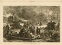
| Date: | 1871 |
|---|---|
| Description: | Drawing of the Peshtigo Fire, showing people seeking refuge in the Peshtigo River. |

| Date: | 1886 |
|---|---|
| Description: | This map shows U.S. land offices, completed railroads, railroad land grant limits, lakes, rivers, and Indian reservations. Communities, lakes, and rivers a... |

| Date: | 1874 |
|---|---|
| Description: | This map shows lakes, rivers, state, county, and town boundaries, as well as railroads completed, in progress, and contemplated. The map includes a color d... |

| Date: | 1870 |
|---|---|
| Description: | During the War of 1812, the only battle fought in Wisconsin was in Prairie du Chien, in 1814. Made fifty-six years later, this birds eye drawing depicts th... |
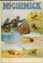
| Date: | 1915 |
|---|---|
| Description: | Advertising poster for McCormick brand farm implements featuring two men paddling a canoe in rough water. Also includes color illustrations of a reaper, ha... |
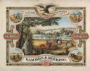
| Date: | 1876 |
|---|---|
| Description: | Color chromolithograph illustration advertising poster for the Marsh Harvester, produced by Gammon and Deering Company. Printed by Charles Shober & Co., Ch... |

| Date: | 1889 |
|---|---|
| Description: | Color lithograph illustration on the back cover of the McCormick Harvesting Machine Company catalog. Shows a buffalo gazing down upon men with harvesting m... |

| Date: | 1803 |
|---|---|
| Description: | Cours du Mississippi : comprenant la Louisiane, les 2 Florides, une partie des Etats-Unis, et pays adjacents. |

| Date: | 1821 |
|---|---|
| Description: | Engraving depicting the Schoolcraft expedition crossing the Ontonagon River to investigate a copper boulder. |

| Date: | 1873 |
|---|---|
| Description: | Map of the township of Windsor, from the "Atlas of Dane County." |
If you didn't find the material you searched for, our Library Reference Staff can help.
Call our reference desk at 608-264-6535 or email us at:


