 Filter: Categories of Wisconsin Historical Images
Filter: FORMAT_TYPE of prints, photomechanical
Filter: Subject of water
Filter: County of Waushara
Filter: Categories of Wisconsin Historical Images
Filter: FORMAT_TYPE of prints, photomechanical
Filter: Subject of water
Filter: County of Waushara

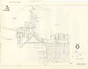
| Date: | 1900 |
|---|---|
| Description: | This 1900 map of Waukesha County, Wisconsin, shows the township and range grid, towns, sections, cities and villages, rural landowners and acreages, railro... |

| Date: | 1850 |
|---|---|
| Description: | The map is ink on tracing cloth. The map shows portions of township 20 north, range 12 east, section 30 (in the Town of Saxeville) and township 20 north, r... |
| Date: | 1960 |
|---|---|
| Description: | This map shows water mains, valves, hydrants, crosses, tees, and elevated tanks. The back of the map reads: "Notice of public hearing from T.H. Schuette, v... |
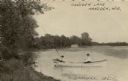
| Date: | 1911 |
|---|---|
| Description: | View along shoreline towards two people in a rowboat on a lake. A man is rowing the boat, while a child is fishing is sitting in the back of the boat, fish... |
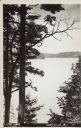
| Date: | 1907 |
|---|---|
| Description: | Text on front reads: "Long Lake, Saxeville, Wis." An elevated view of the lake framed by trees. The far shore can be seen in the distance. |
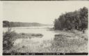
| Date: | 1907 |
|---|---|
| Description: | Text on front reads: "West End, Long Lake, Saxeville, Wis." View of a lake with marshland plants in the foreground. A dock, boat and trees are on the right... |
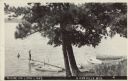
| Date: | 1907 |
|---|---|
| Description: | Text on front reads: "Scene on Long Lake, Saxeville, Wis." A dock is on the shore of a lake with a large tree overhead. One person is on the dock, another ... |

| Date: | 1940 |
|---|---|
| Description: | Text on front reads: "Trout Ponds at the State Hatchery, Wild Rose, Wis." View across ponds lined with trees. In the background on the right are a man and ... |
If you didn't find the material you searched for, our Library Reference Staff can help.
Call our reference desk at 608-264-6535 or email us at: