 Filter: Categories of Wisconsin Historical Images
Filter: FORMAT_TYPE of prints, photomechanical
Filter: Subject of water
Filter: County of Sheboygan
Filter: Categories of Wisconsin Historical Images
Filter: FORMAT_TYPE of prints, photomechanical
Filter: Subject of water
Filter: County of Sheboygan

| Date: | 1885 |
|---|---|
| Description: | Bird's-eye view of Sheboygan, with inset of J.J. Volrath Manufacturing Company. |

| Date: | 1914 |
|---|---|
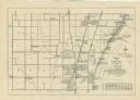
| Description: | This map shows Sheboygan in 1914. The top of the map has the date of "NOV 17 1916" stamped in red ink. The map shows numbered plots and labeled streets, an... |
| Date: | 1910 |
|---|---|
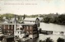
| Description: | Elevated view of the White Wagon Works and Rock Mills. Caption reads: "White Wagon Works and Rock Mills, Sheboygan Falls, Wis." |
| Date: | |
|---|---|
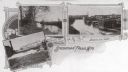
| Description: | Three scenes of the city. Captions read: "The Falls," "Scene on Sheboygan River" and "Bird's Eye View." |
| Date: | 1925 |
|---|---|
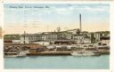
| Description: | View across water towards the Phoenix Chair factory on the waterfront. Caption reads: "Phoenix Chair Factory, Sheboygan, Wis." |
| Date: | 1909 |
|---|---|
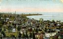
| Description: | Elevated view of town on Lake Michigan. Caption reads: "Sheboygan, Wis. North Point on Lake Michigan." |

| Date: | |
|---|---|
| Description: | View from shoreline towards a passenger train crossing a bridge near the Sheboygan Mineral Water Company Bottling Works building. Caption reads: Passenger ... |
| Date: | 1910 |
|---|---|
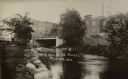
| Description: | View of the Mullet River, with an bridge and an industrial building in the background. A sign reads, in part: "MFG. CO." |
| Date: | 1951 |
|---|---|
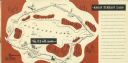
| Description: | A drawing of the 5.3 mile race course around Elkhart Lake. Page 12 and 13 of the official program from Elkhart Lake Road Race. The race took place on Sunda... |

| Date: | 1857 |
|---|---|
| Description: | This map of Sheboygan Harbor shows the river mouth and harbor, piers, wharfs, piles of old destroyed bridge wharfs, streets, and the lake shore from survey... |
| Date: | |
|---|---|
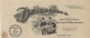
| Description: | Letterhead of The Dutch Canning Company of Cedar Grove, Wisconsin, "Packers of Fancy Corn Peas and Beans," with a boy and girl in traditional clothing and ... |
| Date: | 1941 |
|---|---|
| Description: | A map shows early settlers by name and date, industries, the Chicago & North Western rail line, roads, and depths and net lines in Lake Michigan. Text prov... |

| Date: | 1836 |
|---|---|
| Description: | This 1836 map consists chiefly of a detailed map of the the mouth of the Sheboygan River. An inset map of the region and cross section diagrams of the pier... |

| Date: | 1862 |
|---|---|
| Description: | This 1862 map of Sheboygan County, Wisconsin, shows land ownership and acreages, the township and range grid, towns, cities and villages, roads, railroads,... |

| Date: | 1934 |
|---|---|
| Description: | This 1930s highway map of Sheboygan County, Wisconsin, shows roads, the township and range grid, towns, sections, cities and villages, and streams, lakes, ... |

| Date: | 1906 |
|---|---|
| Description: | This map of Sheboygan County, Wisconsin, from the early 20th century shows school districts and school locations in the county. Also shown are the township... |

| Date: | 1972 |
|---|---|
| Description: | This map of Sheboygan County, Wisconsin, shows the location of churches in the county. Churches are indexed for each town. Also shown are sections, cities ... |

| Date: | 1898 |
|---|---|
| Description: | This map shows the contour depths of Elkhart Lake in the Town of Rhine, Sheboygan County, Wisconsin, and includes two cross sections of the lake. The villa... |
If you didn't find the material you searched for, our Library Reference Staff can help.
Call our reference desk at 608-264-6535 or email us at:

