 Filter: Categories of Wisconsin Historical Images
Filter: FORMAT_TYPE of prints, photomechanical
Filter: Subject of water
Filter: County of Rock
Filter: Categories of Wisconsin Historical Images
Filter: FORMAT_TYPE of prints, photomechanical
Filter: Subject of water
Filter: County of Rock

| Date: | 1874 |
|---|---|
| Description: | Bird's-eye view of Beloit, with insets of Beloit College, Beloit High School, and Memorial Hall. |

| Date: | 1877 |
|---|---|
| Description: | Bird's-eye map of Janesville on the Rock River. |
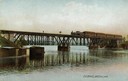
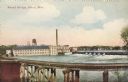
| Date: | |
|---|---|
| Description: | The railroad bridge over the Rock River. |
| Date: | 1905 |
|---|---|
| Description: | View of the dam and power plant over the river, with smokestacks in the background. Caption reads: "The Dam, Beloit, Wis." |
| Date: | 1905 |
|---|---|
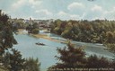
| Description: | Elevated view of the river, with railroad tracks on the left shoreline, and a railroad bridge crossing the river. Caption reads: "View of River from Grand ... |
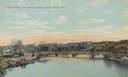
| Date: | 1905 |
|---|---|
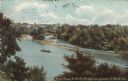
| Description: | View of the Rock River with the Northwestern Railroad Bridge in the foreground and Beloit in the background. Caption reads: "Bird's-Eye View of River, Belo... |
| Date: | 1905 |
|---|---|
| Description: | Elevated view of the Rock River. Caption reads: "Rock River, N.W. Ry. Bridge, and glimpse of Beloit, Wis." |
| Date: | 1900 |
|---|---|
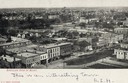
| Description: | Elevated view of downtown. Caption reads: "Bird's-eye view of Beloit." |
| Date: | 1905 |
|---|---|
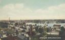
| Description: | View towards river. Caption reads: "Bird's Eye View, Beloit, Wis." |

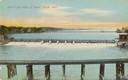
| Date: | 1905 |
|---|---|
| Description: | View across the dam in Janesville. Caption reads: "The Dam, Janesville, Wis." |

| Date: | |
|---|---|
| Description: | View across river and bridges towards Janesville. Caption reads: "Greetings from Janesville, Wis., U. S. A." Text at bottom reads: "Panorama." |

| Date: | 1908 |
|---|---|
| Description: | View towards people standing on the shoreline near a boat landing at Yosts Park. A man and a dog are standing on the pier, and a group of people are in a b... |

| Date: | 1858 |
|---|---|
| Description: | This 1858 map of Rock County, Wisconsin, shows the township and range grid, towns, sections, cities and villages, railroads, roads, property owners and res... |

| Date: | 1853 |
|---|---|
| Description: | Map covers area between the cities of Janesville and Kenosha in Rock, Walworth, and Kenosha counties for railroad routes. Lakes and counties are labelled. ... |

| Date: | |
|---|---|
| Description: | Colorized postcard view through trees towards the Rock River, with a railroad bridge running across it in the distance. Beyond are factories and commercial... |

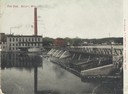
| Date: | |
|---|---|
| Description: | Colorized postcard view of the iron works and river. There is another factory on the opposite side of the river behind the trees on the right. |
| Date: | 1909 |
|---|---|
| Description: | Colorized postcard of an elevated view through trees of the Rock River, with a railroad bridge and a glimpse of Beloit. There are boaters near sandbars in ... |
| Date: | |
|---|---|
| Description: | Colorized postcard of an elevated view of the Round Bridge, part of the C.M. and St. Paul R.R. A factory and dam are in the background and dwellings are on... |

| Date: | 1910 |
|---|---|
| Description: | Colorized postcard view from riverbank of the Upper Bridge crossing the Rock River into Beloit. A man is in a rowboat in the foreground. In the background ... |
If you didn't find the material you searched for, our Library Reference Staff can help.
Call our reference desk at 608-264-6535 or email us at:
