 Filter: Categories of Wisconsin Historical Images
Filter: FORMAT_TYPE of prints, photomechanical
Filter: Subject of water
Filter: County of Racine
Filter: Categories of Wisconsin Historical Images
Filter: FORMAT_TYPE of prints, photomechanical
Filter: Subject of water
Filter: County of Racine

| Date: | 1874 |
|---|---|
| Description: | Bird's-eye map of Racine, with an inset of Racine College. |

| Date: | 1906 |
|---|---|
| Description: | View of Horlick's mill and dam, also known as "Ye Old Mill." |
| Date: | |
|---|---|
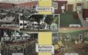
| Description: | Color postcard of five views of Liggett's Resort on Brown's Lake. Front view, "Marine Dining Room," "Marine Bar," "Guest Room" and "Marine Lounge." |

| Date: | |
|---|---|
| Description: | Black and white postcard of a river view of the Fox River as it runs through the city of Burlington. In the foreground is a railroad bridge. Just behind th... |

| Date: | 05 25 1905 |
|---|---|
| Description: | Black and white postcard of a view of the Fox River as it flows through Burlington. The shoreline is wooded. Red text below reads: "View of Fox River, Burl... |

| Date: | 09 02 1908 |
|---|---|
| Description: | Black and white postcard of the Mill Dam. The water is running over the dam from the left and becoming rapids on the right. There is a wooded shoreline on ... |

| Date: | 1972 |
|---|---|
| Description: | This map on 5 sheets features a title page sheet with business directory and shows section numbers, roads, railroads, saw mills, churches, blacksmith shops... |
| Date: | |
|---|---|
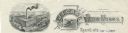
| Description: | Memohead of the J.I. Case Plow Works of Racine, Wisconsin, with an elevated view of the company plant and a smaller scene set on a scroll of a man driving ... |
| Date: | 1918 |
|---|---|
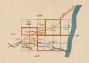
| Description: | This map shows the property owned by Edwin Bottomley and others at the confluence of Eagle Creek with the Fox River in the Town of Rochester, Racine County... |

| Date: | 1858 |
|---|---|
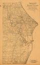
| Description: | This 1858 map of Racine County, Wisconsin, shows land ownership and acreages, the township and range grid, towns, cities and villages, roads, railroads, sc... |
| Date: | 1893 |
|---|---|
| Description: | This 1893 map of the eastern portion of Racine County, Wisconsin, shows land ownership and acreages, railroads, and roads in the towns of Caledonia and Mou... |

| Date: | 1896 |
|---|---|
| Description: | This 1896 map of Racine and Kenosha counties, Wisconsin, shows the township and range grid, towns, sections, cities, villages and post offices, roads, rail... |

| Date: | 1934 |
|---|---|
| Description: | This 1934 map of Racine County, Wisconsin, shows the township and range grid, cities and villages, vegetation type, land use, roads, railroads, utilities, ... |

| Date: | |
|---|---|
| Description: | Hand-colored postcard view of the Reef Lighthouse in Lake Michigan off the shore of Racine. A person is standing to the left of the lighthouse. Caption rea... |
| Date: | |
|---|---|
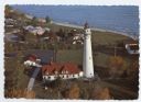
| Description: | Aerial view of Wind Point lighthouse on the shore of Lake Michigan. A few neighboring homes are in the foreground. Some of the trees are displaying fall co... |

| Date: | 1987 |
|---|---|
| Description: | This 1987 map of Racine and Kenosha counties, Wisconsin, shows towns, sections, cities and villages, zip code boundaries, highways and roads, bicycle route... |
| Date: | |
|---|---|
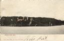
| Description: | Colorized view of Brown's Lake. Buildings on the far shoreline are obscured by trees. Caption reads: "Brown's Lake, Wis." |

| Date: | |
|---|---|
| Description: | Color reproduction of a painting of a river in the mountains. Two people are standing near the river. Caption reads: "Greetings from Burlington, Wis. A Sum... |

| Date: | 1909 |
|---|---|
| Description: | View of a camp by Bohner's Lake. Caption reads: "East Shore Bohner's Lake, Burlington." |

| Date: | 1942 |
|---|---|
| Description: | This map of Burlington shows plat of the town, city limits, section lines, 1/4 section lines of the plat sections, roads, railroads, rivers, and lakes. The... |
If you didn't find the material you searched for, our Library Reference Staff can help.
Call our reference desk at 608-264-6535 or email us at: