 Filter: Categories of Wisconsin Historical Images
Filter: FORMAT_TYPE of prints, photomechanical
Filter: Subject of water
Filter: Creator Name of Unknown
Filter: Categories of Wisconsin Historical Images
Filter: FORMAT_TYPE of prints, photomechanical
Filter: Subject of water
Filter: Creator Name of Unknown
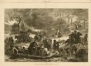
| Date: | 11 25 1871 |
|---|---|
| Description: | Engraved view of Peshtigo Fire showing people trying to escape the flames by boat and on horseback. A team of cattle also seek refuge and several birds tak... |

| Date: | 1823 |
|---|---|
| Description: | In 1823 U.S. Army major Stephen H. Long led an expedition of scientific, trade, and military investigation up the Mississippi River and the Red River of th... |

| Date: | 1852 |
|---|---|
| Description: | Illustration of four Indians on Madeline Island with a canoe in the water on the shore. |

| Date: | 1884 |
|---|---|
| Description: | A sign for Fauerbach's Brewery depicting a young woman and the brewery. |
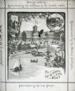
| Date: | 1883 |
|---|---|
| Description: | Tonyawatha Spring Hotel from a descriptive brochure. The hotel opened in 1879 and was destroyed by fire on July 31, 1895. |
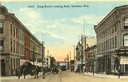
| Date: | 1910 |
|---|---|
| Description: | Colorized view of King Street, looking east, with a streetcar. Lake Monona is in the background. Caption reads: "King Street, looking East, Madison, Wis." |

| Date: | 1873 |
|---|---|
| Description: | Map of the township of Windsor, from the "Atlas of Dane County." |

| Date: | 1930 |
|---|---|
| Description: | Page 8 of the 1930 schedule is a map of the routes of the Goodrich Steamship Lines in Lake Michigan and Lake Huron. |
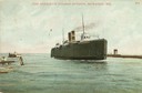
| Date: | |
|---|---|
| Description: | The screw rail ferry, Pere Marquette 18, entering the harbor. Caption reads: "Pere Marquette Steamer Entering, Milwaukee, Wis." |
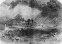
| Date: | 09 22 1860 |
|---|---|
| Description: | Sketch from the "New York Illustrated News" of the sinking of the sidewheel passenger, Lady Elgin. She was struck and sunk by the Augusta on ... |
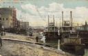
| Date: | 1900 |
|---|---|
| Description: | Riverboats tied at the levee in La Crosse with the Gypsy in the foreground. Caption reads: "The Levee, La Crosse, Wis." |
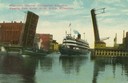
| Date: | |
|---|---|
| Description: | Colorized view depicting the passenger excursion vessel, "Christopher Columbus," approaching the East Water Street Bridge. Caption reads: "Whaleback Steame... |

| Date: | 1861 |
|---|---|
| Description: | Drawn the first year of the Civil War, this colored 1861 map of Dane County shows its towns, cities and lakes. It includes insets of the wards of Madison a... |
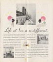
| Date: | 1931 |
|---|---|
| Description: | Describes the amenities aboard the "North American" and "South American". |

| Date: | 1862 |
|---|---|
| Description: | Drawn the second year of the Civil War, this 1862 map of Milwaukee shows post offices, light houses, beacon lights, county buildings, elevator warehouses, ... |

| Date: | 1876 |
|---|---|
| Description: | Bird's-eye view of Black Earth. |

| Date: | 1910 |
|---|---|
| Description: | Map of Dane County rural delivery in Madison and the town of Westport. |

| Date: | 1839 |
|---|---|
| Description: | A map of the Wiskonsin [sic] and Neenah or Fox Rivers. |
If you didn't find the material you searched for, our Library Reference Staff can help.
Call our reference desk at 608-264-6535 or email us at:

