 Filter: Categories of Wisconsin Historical Images
Filter: FORMAT_TYPE of prints, photomechanical
Filter: Subject of transportation
Filter: County of Ozaukee
Filter: Categories of Wisconsin Historical Images
Filter: FORMAT_TYPE of prints, photomechanical
Filter: Subject of transportation
Filter: County of Ozaukee
| Date: | 1907 |
|---|---|
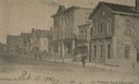
| Description: | View across Washington Avenue. A man is standing in the street near the curb. Caption reads: "Cedarburg, Wis., Washington Avenue looking North." |
| Date: | 1905 |
|---|---|
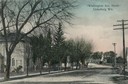
| Description: | North view down Washington Avenue. Caption reads: "'Washington Ave., North' Cedarburg Wis." |
| Date: | 1940 |
|---|---|
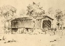
| Description: | Drawing of a covered bridge in Cedarburg. |
| Date: | 1850 |
|---|---|
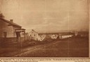
| Description: | Main Street in Cedarburg. Includes text which reads: "Cedarburg, Wis., in the year 1850, showing Main Street as it appeared at that time. The photograph wa... |

| Date: | 1915 |
|---|---|
| Description: | View across road towards the Ozaukee County Court House. Caption reads: "Court House, Port Washington, Wis." |
| Date: | |
|---|---|
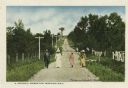
| Description: | Well-dressed group of three women and one man walking along a dirt road lined with fences and telephone poles. Caption reads: "A Stroll through Donges Bay.... |
| Date: | |
|---|---|
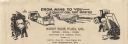
| Description: | Letterhead of the West Side Fuel Company of Port Washington, Wisconsin, with cartoon-style drawings, printed in black ink, of workers mining coal with a pi... |

| Date: | 1961 |
|---|---|
| Description: | This 1961 map of Ozaukee County, Wisconsin, identifies historic sites and landmarks in the county. Cities and villages, roads, and lakes and streams are al... |
| Date: | |
|---|---|
| Description: | Postcard view along icy shoreline of the pier and lighthouse on Lake Michigan at Port Washington in winter. |
| Date: | |
|---|---|
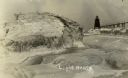
| Description: | Winter postcard view of the pier and lighthouse at Port Washington seen from the icy shore of Lake Michigan. Caption reads: "Light House." |
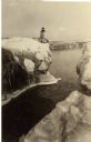
| Date: | |
|---|---|
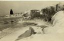
| Description: | Winter view of the lighthouse at Port Washington from the icy shore of Lake Michigan. Two people can be seen standing on a pier in the distance. |

| Date: | 1910 |
|---|---|
| Description: | Postcard view of three men on an elevated walk on an icy pier near the shoreline. A women and young boy stand on the pier below the walk. There is a lighth... |

| Date: | 1967 |
|---|---|
| Description: | This map of Cedarburg includes a list of historic buildings in the left margin. The map was created by the Ozaukee County Historical Society for Cedarburg'... |

| Date: | 1938 |
|---|---|
| Description: | This map shows plat of town, boundary lines of assessors blocks, land ownership by name, local streets, railroads, wards, lots, and parts of Cedar Creek. T... |

| Date: | 1876 |
|---|---|
| Description: | This map shows existing and proposed harbor improvements, streets, the Sauk River, and Lake Michigan. On the bottom of the map inscribed in ink is: "44th C... |

| Date: | 1989 |
|---|---|
| Description: | This pictorial map shows Lake Michigan, businesses with phone numbers, schools, parks, other points of interest, and includes a brief history of the town. ... |

| Date: | 1960 |
|---|---|
| Description: | This blue line print map shows zone districts, lot and block numbers and dimensions, building setbacks, center lines of streets, and some landownership. Th... |
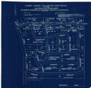
| Date: | 04 1958 |
|---|---|
| Description: | This blueprint map shows additions, sections, and streets. The upper left of the map reads: "Plan for 6ʺ watermain, hydrants & appurtenances." The up... |

| Date: | 1962 |
|---|---|
| Description: | View from side of road towards the covered bridge, with the historical marker on the right. "This bridge was built by the town of Cedarburg on petition of ... |
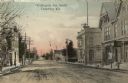
| Date: | |
|---|---|
| Description: | Hand-colored view down center of Washington Avenue, facing south, towards a church building on the horizon. The street is lined with sidewalks, buildings a... |
If you didn't find the material you searched for, our Library Reference Staff can help.
Call our reference desk at 608-264-6535 or email us at: