 Filter: Categories of Wisconsin Historical Images
Filter: FORMAT_TYPE of prints, photomechanical
Filter: Subject of transportation
Filter: County of Lafayette
Filter: Categories of Wisconsin Historical Images
Filter: FORMAT_TYPE of prints, photomechanical
Filter: Subject of transportation
Filter: County of Lafayette

| Date: | 1881 |
|---|---|
| Description: | Darlington's first settlers arrived by 1826, attracted by the lead mines of the area. Arrival of the railroad in 1856 stimulated growth, and in 1857 the co... |

| Date: | 1896 |
|---|---|
| Description: | Bird's-eye map of Darlington. Area bordered by Washington and North Streets, upper left hand corner, the fairgrounds, upper right corner, River Street, bot... |
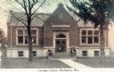
| Date: | 1914 |
|---|---|
| Description: | View toward the front of the Carnegie Library. A group of people are posing on the steps. Caption reads: "Carnegie Library, Darlington, Wis." |
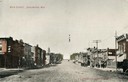
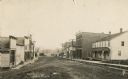
| Date: | 1905 |
|---|---|
| Description: | View down center of unpaved Main Street with storefronts on both sides. A group of people are on the sidewalk on the right. Caption reads: "Main Street, Da... |
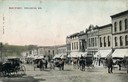
| Date: | 1910 |
|---|---|
| Description: | View across unpaved street towards storefronts on the right. There are horse-drawn carriages and pedestrians moving up and down the street. Caption reads: ... |
| Date: | 1905 |
|---|---|
| Description: | View down street towards Soldiers' Monument. Caption reads: "Soldiers' Monument, Darlington, Wis." |
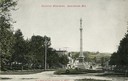
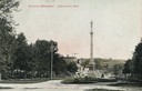
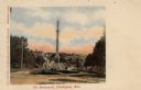
| Date: | 1907 |
|---|---|
| Description: | View down road looking towards Soldiers' Monument and town beyond. Caption reads: "Soldiers' Monument, Darlington, Wis." |
| Date: | 1900 |
|---|---|
| Description: | View down unpaved Main Street with storefronts are along both sides. A sign on a building further down on the right reads: "Nixon House". Caption reads: "S... |

| Date: | 1836 |
|---|---|
| Description: | Lots to be sold at auction by Van Antwerp and Van Dyke on Monday, 3rd Oct. 1836. The map shows plots and labeled streets. Iowa County was later split and B... |
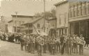
| Date: | 1906 |
|---|---|
| Description: | Brass marching band in uniforms and spectators at a Memorial Day parade. The band and spectators stand in the road outside city shops and business, includi... |

| Date: | 1866 |
|---|---|
| Description: | A map of Lafayette County, Wisconsin, showing the townships and ranges, sections, towns, villages, stream and rivers, mounds, mineral deposits and the Mine... |

| Date: | 1990 |
|---|---|
| Description: | A tourist map of Lafayette County, Wisconsin, that shows the locations of motels, camping, municipal parks, cheese factory tours, waysides, and golf course... |

| Date: | 1850 |
|---|---|
| Description: | Ink on paper. Shows local streets and Pekatonika River. "John M. Keep, proprietor. "Original plat of Darlington as surveyed by Richardson on June 14, 1850.... |

| Date: | 1904 |
|---|---|
| Description: | Map shows townships and sections, landownership and acreages, roads, railroads, post offices, and farms. On the top, bottom, and sides of map are advertise... |

| Date: | 1836 |
|---|---|
| Description: | This map of Belmont includes notarization from the justice of the peace of Iowa County, May 15, 1836, acknowledging John Atchison as proprietor of Belmont ... |

| Date: | 1855 |
|---|---|
| Description: | This map is ink, pen, and watercolor on paper and shows plat of the town, local streets, lots by number, U.S. subdivisions in red lines, Mineral Point Rail... |
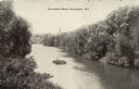
| Date: | 1910 |
|---|---|
| Description: | Elevated view looking up the Pecatonica River. Caption reads: "Pecatonica River, Darlington, Wis." |

| Date: | 1910 |
|---|---|
| Description: | Aerial view along river toward Darlington. Caption reads: "Bird's-Eye View, Darlington, Wis." |
| Date: | 1910 |
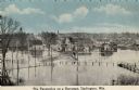
|---|---|
| Description: | Elevated view of the Pecatonica River at the bridge. The river is flooding the town. Caption reads: "Pecatonica River on a Rampage, Darlington, , Wis." |
| Date: | 1910 |
|---|---|
| Description: | View down hill toward the Soldier's Monument. Caption reads: "The Monument, Darlington, Wis." |
If you didn't find the material you searched for, our Library Reference Staff can help.
Call our reference desk at 608-264-6535 or email us at: