Filter: Categories of Wisconsin Historical Images
Filter: FORMAT_TYPE of prints, photomechanical
Filter: Subject of transportation
Filter: County of Iowa
Filter: Categories of Wisconsin Historical Images
Filter: FORMAT_TYPE of prints, photomechanical
Filter: Subject of transportation
Filter: County of Iowa
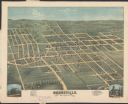
| Date: | 1875 |
|---|---|
| Description: | Bird's-eye map of Dodgeville, looking east, with insets of the high school and county courthouse. |
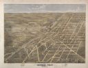
| Date: | 1872 |
|---|---|
| Description: | Bird's-eye map of Mineral Point, looking southeast. |
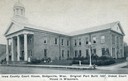
| Date: | 1935 |
|---|---|
| Description: | Iowa County court house with people sitting on the lawn. The wing on the right was added in 1927. Caption reads: "Iowa County Court House, Dodgeville, Wisc... |

| Date: | 1856 |
|---|---|
| Description: | Wisconsin map illustrating the Mineral Point Railroad and its connections. |

| Date: | 1915 |
|---|---|
| Description: | View down street, with storefronts on both sides. Caption reads: "High Street looking west from Dellars Corner, Mineral Point, Wis." |

| Date: | 1905 |
|---|---|
| Description: | A watertower in Mineral Point. Caption reads: "Watertower, Mineral Point, Wis." |

| Date: | |
|---|---|
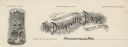
| Description: | Memohead of Strong's Bank, of Dodgeville, Wisconsin, with a three-quarter view of the bank building. There are people standing on the sidewalk, and two hor... |
| Date: | |
|---|---|
| Description: | Letterhead of the Dodgeville (State) Bank, with a front view of the bank building. There is a datestone at the top of the bank building that reads: "1895" ... |

| Date: | 1870 |
|---|---|
| Description: | A map of Iowa County, Wisconsin mounted on cloth that shows the villages of Avoca, Mifflin, Linden, Arena, Helena Station, Highland, Dodgeville, as well as... |

| Date: | 1901 |
|---|---|
| Description: | A hand-colored map of Iowa County, Wisconsin, shows townships and sections, towns, cities and villages, streams, landownership, roads, railroads and rural ... |

| Date: | 1836 |
|---|---|
| Description: | This early to mid-19th century map shows the township and range system, sections, landownership, furnaces, lead mines, copper mines, and roads in the vicin... |

| Date: | 1956 |
|---|---|
| Description: | Shows roads, railroads, highways, boundaries, and other public facilities and areas. Includes location map and legend. "Corrected for Feb. 1956." "Correcte... |

| Date: | 1840 |
|---|---|
| Description: | This map shows local streets, numbered lots, and part of Blue Mounds Branch. The map reads: "NE 1/4 NW 1/4 Sect. 16 - T5 - R5E." under the title and is dat... |

| Date: | 1910 |
|---|---|
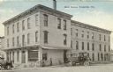
| Description: | Elevated view of busy Iowa Street scene, looking north, with the Hotel Higbee on the left, and the Iowa County Courthouse in the background. Caption reads:... |

| Date: | 1910 |
|---|---|
| Description: | Elevated view of a busy street scene on Iowa Street, looking north. The Higbee Hotel is on the left side of the street, and the Iowa County Courthouse is i... |

| Date: | 1920 |
|---|---|
| Description: | Iowa Street, looking south, with the Iowa County Courthouse on the right. Automobiles are parked at an angle on both sides of the street. Caption reads: "S... |
| Date: | 08 06 1919 |
|---|---|
| Description: | View from street looking towards the Hotel Higbee. There is a horse-drawn carriage on the left side, and a large, motorized vehicle, perhaps a bus, parked ... |

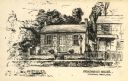
| Date: | 1920 |
|---|---|
| Description: | Slightly elevated photographic postcard view of the General Hospital. Caption reads: "General Hospital, Dodgeville, Wisc." |
If you didn't find the material you searched for, our Library Reference Staff can help.
Call our reference desk at 608-264-6535 or email us at: