 Filter: Categories of Wisconsin Historical Images
Filter: FORMAT_TYPE of prints, photomechanical
Filter: Subject of transportation
Filter: County of Dunn
Filter: Categories of Wisconsin Historical Images
Filter: FORMAT_TYPE of prints, photomechanical
Filter: Subject of transportation
Filter: County of Dunn
| Date: | 1912 |
|---|---|
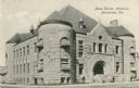
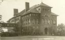
| Description: | The Mabel Tainter Memorial building designed by Harvey Ellis. Caption reads: "Mabel Tainter Memorial, Menominee, Wis." |

| Date: | 1905 |
|---|---|
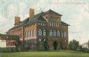
| Description: | Stout State College Bowman Building with clock tower. It is attached to the central school building by a second-story bridge. Caption reads: "Stous Manual ... |
| Date: | 1905 |
|---|---|
| Description: | The Central School building is attached to the Bowman Building by a second-story bridge on the left. Caption reads: "Central School Menomonie, Wis." |
| Date: | |
|---|---|
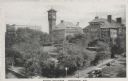
| Description: | Elevated view of school buildings in Menomonie, later a part of the Stout State College. The building in the center has a clock tower. Caption reads: "Scho... |

| Date: | 1910 |
|---|---|
| Description: | Exterior of Masonic Temple. Caption reads: "Masonic Temple, Menomonie, Wis." |

| Date: | 1920 |
|---|---|
| Description: | View down Main Street. Caption reads: "Main Street, Menomonie, Wis." |

| Date: | 1920 |
|---|---|
| Description: | View looking toward Main and Crescent Streets. Caption reads: "Main and Crescent Streets, Menomonie, Wis." |
| Date: | 11 02 1912 |
|---|---|
| Description: | View across unpaved road towards the gymnasium and natatorium. Caption reads: "Gymnasium and Natatorium, Menominee, Wis." |

| Date: | 1910 |
|---|---|
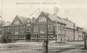
| Description: | The Dunn County Normal and Agricultural School. Caption reads: "Normal, Menomonie, Wis." |

| Date: | 1910 |
|---|---|
| Description: | Elevated view across rooftops towards the dam on the Red Cedar River, also showing the electric power plant and mills. Caption reads: "Lake and Falls, Meno... |

| Date: | 1908 |
|---|---|
| Description: | Elevated view of the dam on the Red Cedar River, also showing the electric power plant and mills. Caption reads: "Bridge, Falls, Electric Power House and t... |
| Date: | 1915 |
|---|---|
| Description: | The Central School, later a part of Stout State College. Caption reads: "Central School, Menomonie, Wis." |

| Date: | 1920 |
|---|---|
| Description: | View down center of street. Caption reads: "North Broadway, Menomonie, Wis." |

| Date: | 1920 |
|---|---|
| Description: | View down center of street. Caption reads: "North Broadway, Menomonie, Wis." |
| Date: | 1927 |
|---|---|
| Description: | Shows section corners, landownership and acreages, roads, railroad, Weston village, and buildings of W.J. Starr Estate. Relief shown by hachures. "Map comp... |

| Date: | 1970 |
|---|---|
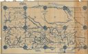
| Description: | This pictorial map of Dunn County, Wisconsin, from the 1970s depicts historical events that occurred in the county. It shows cemeteries, churches, schools,... |
| Date: | 1930 |
|---|---|
| Description: | Map reads: "Plat showing Location of Creamery on apart of The NorthEast 1/4 of the NorthWest 1/4 of Sec 31, T. 30 N.R. 14 W. The map notes creamery buildin... |

| Date: | 1855 |
|---|---|
| Description: | Map reads: "Knapp, Stout & Co., William Carson, Henry Eaton, Amos Collum, William Wilson & C.S. Bundy Proprietors."Streets running horizontally begin at th... |

| Date: | 1890 |
|---|---|
| Description: | Shows plat of town, local streets, steam boat landings, and Chippewa River. Public square and Muskoo Island hand-colored. Map reads: "Full Lots are 125x66 ... |

| Date: | 1960 |
|---|---|
| Description: | This map shows lot and block numbers, additions, and rural acreages and includes an index of rail roads, industrial plants, Dunn County and Menominee owned... |
If you didn't find the material you searched for, our Library Reference Staff can help.
Call our reference desk at 608-264-6535 or email us at: