 Filter: Categories of Wisconsin Historical Images
Filter: FORMAT_TYPE of prints, photomechanical
Filter: Subject of taverns (inns)
Filter: Categories of Wisconsin Historical Images
Filter: FORMAT_TYPE of prints, photomechanical
Filter: Subject of taverns (inns)

| Date: | 1910 |
|---|---|
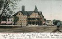
| Description: | Chippewa Falls from the south side of the river below the falls. Includes the Sheely House Tavern, railway buildings, box cars, a train with five passenger... |
| Date: | 1900 |
|---|---|
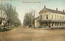
| Description: | View down road towards the Elkhorn House. Caption reads: "Elkhorn Hosue, Elkhorn, Wis." |

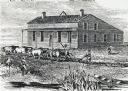
| Date: | 1837 |
|---|---|
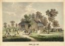
| Description: | Fond du Lac Company House, built in 1836 and operated as an inn by Colwert Pier and his wife. Groups of Indians are in the yard outside the inn, and severa... |
| Date: | 1837 |
|---|---|
| Description: | Fond du Lac Company House. Groups of Indians are in the yard outside the inn, and several Indian dwellings are erected next to it. A man on horseback with ... |
| Date: | |
|---|---|
| Description: | View of an intersection of dirt roads, with a large building, possibly an inn or apartment building on the right corner. A carriage or car is parked near t... |
| Date: | 1910 |
|---|---|
| Description: | View up dirt road toward Rhoade's House. Caption reads: "Rhoade's House, Medina, Wis." |
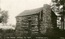
| Date: | 1920 |
|---|---|
| Description: | A view of the cabin on the property of the Milton House, which was a part of the Underground Railroad prior to the abolition of slavery. The house was buil... |

| Date: | |
|---|---|
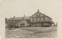
| Description: | Exterior view of the Wilmot Stage Stop inn, which was established in 1848. |
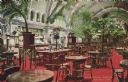
| Date: | 07 03 1886 |
|---|---|
| Description: | Hand-colored postcard of the interior of the Schlitz Palm Garden. Located on N. 3rd Street, south of W. Wisconsin Avenue, the Schlitz Palm Garden opened on... |

| Date: | 1835 |
|---|---|
| Description: | Two-story home with sloping roof. One man is whipping a team of eight cattle while another man drives the plow behind them. To the left stands a man near a... |
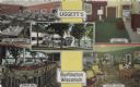
| Date: | |
|---|---|
| Description: | Color postcard of five views of Liggett's Resort on Brown's Lake. Front view, "Marine Dining Room," "Marine Bar," "Guest Room" and "Marine Lounge." |
| Date: | 1864 |
|---|---|
| Description: | This map depicts the battlefield at Todd's Tavern, Va., the site of a battle on May 7-8, 1864. Depicted are roads, houses, drainage, vegetation and troop p... |

| Date: | 1930 |
|---|---|
| Description: | Pen and ink map on paper of Wisconsin and northern Illinois showing stagecoach routes (marked in red) that traveled between Lake Michigan and the Mississip... |
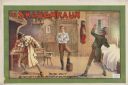
| Date: | 1875 |
|---|---|
| Description: | Color lithograph on paper. Title across top in caps. Below it a scene in a pub featuring three men, with the central figure propping a foot on a wooden buc... |

| Date: | 1870 |
|---|---|
| Description: | This 1870 map of Brown County, Wisconsin, shows the township and range grid, towns, sections, cities, villages and post offices, land ownership, roads, rai... |

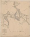
| Date: | 1941 |
|---|---|
| Description: | This 1941 map covers Washburn County, Wisconsin, as well as western Sawyer, eastern Burnett, and northeastern Polk counties. It shows the locations of tour... |
| Date: | 1840 |
|---|---|
| Description: | Sod-breaker and five yoke of oxen plowing in front of the “Old Cottage Inn.” In the foreground a boat is on the shoreline. |

| Date: | 1856 |
|---|---|
| Description: | This map is ink and watercolor on tracing paper and shows plat of city, local streets, block numbers, topography, several buildings, and includes an explan... |

| Date: | 06 12 1929 |
|---|---|
| Description: | This manuscript blueprint shows buildings with the names of their owners, tabernacle, location "where Strang found plates" and "house where Strang died," a... |
If you didn't find the material you searched for, our Library Reference Staff can help.
Call our reference desk at 608-264-6535 or email us at:
