Filter: Categories of Wisconsin Historical Images
Filter: FORMAT_TYPE of prints, photomechanical
Filter: Subject of streams
Filter: Categories of Wisconsin Historical Images
Filter: FORMAT_TYPE of prints, photomechanical
Filter: Subject of streams

| Date: | 1874 |
|---|---|
| Description: | This map shows lakes, rivers, state, county, and town boundaries, as well as railroads completed, in progress, and contemplated. The map includes a color d... |
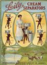
| Date: | 1913 |
|---|---|
| Description: | Advertising poster for Lily brand cream separators featuring a color illustration of a woman operating a hand crank cream separator. Below is a scene of co... |

| Date: | 1966 |
|---|---|
| Description: | Advertising poster for the International Scout 800 truck. Includes a color photograph of the two men in a truck crossing a stream and the text: "Fisherman'... |
| Date: | 1896 |
|---|---|
| Description: | Back cover of an advertising catalog for the Milwaukee Harvester Company. The cover features a color chromolithograph illustration of young boys racing hom... |

| Date: | 1871 |
|---|---|
| Description: | Birds eye map of Brodhead, WI depicts street names and street locations, houses, and trees. A reference key at the bottom of the map shows the locations of... |

| Date: | 1914 |
|---|---|
| Description: | Cover of an advertising catalog for Deering Corn Machines manufactured by International Harvester. Features an illustration of a small bridge over a stream... |
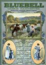
| Date: | 1913 |
|---|---|
| Description: | Calendar advertising International Harvester's Bluebell brand Cream Harvester (more commonly called a cream separator). Features a large illustration of tw... |
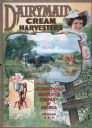
| Date: | 1912 |
|---|---|
| Description: | Advertising poster for the Dairymaid cream harvester (cream separator). Features color illustrations of grazing cows near a stream, a woman with a pail ov... |

| Date: | 1930 |
|---|---|
| Description: | Pictorial map of Glacier National Park, Montana and Waterton Lakes National Park, Alberta. Illustrated by Joe Scheurle, it depicts white people, American ... |

| Date: | 1930 |
|---|---|
| Description: | The back of the pictorial map titled Recreational Map of Glacier National Park, Montana: Waterton Lakes National Park, Alberta. 14 panels of text and photo... |

| Date: | 10 1884 |
|---|---|
| Description: | Sanborn insurance map of Black River Falls covering the area bordered by the Black River on the East, 3rd Street on the West, Johnson Street on the North, ... |

| Date: | 1943 |
|---|---|
| Description: | Holiday card with two flamingos standing in a stream with water lilies. Palm trees are on the banks. The right edge is die cut. |
| Date: | 11 31 1910 |
|---|---|
| Description: | Colorized postcard view of The Spring in Decatur Park. A man is sitting near the spring. There is a bridge on the right, and many trees. Text in red in the... |
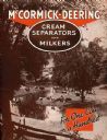
| Date: | 1937 |
|---|---|
| Description: | Cover of an advertising brochure for the McCormick-Deering cream separators and milking machines (milkers). Includes the text: "For One Cow or a Hundred" a... |

| Date: | 1918 |
|---|---|
| Description: | Map of Wisconsin along with the western portion of Michigan’s Upper Peninsula, showing county lines, cities and villages, lakes, streams, and railroads. Po... |

| Date: | |
|---|---|
| Description: | Letterhead of Madison Mobile Homes, with a three-quarter view of a mobile home parked in a clearing near a wooded area on a shoreline, with the slogan "Liv... |

| Date: | 1917 |
|---|---|
| Description: | A geological survey map of southeastern Wisconsin that shows the configuration of the bedrock beneath the glacial drift and other deposits in southeastern ... |

| Date: | 1917 |
|---|---|
| Description: | A geological survey map that map of southeastern Wisconsin shows the surface deposits east of the Wisconsin River, from the Illinois state line north to Ne... |
If you didn't find the material you searched for, our Library Reference Staff can help.
Call our reference desk at 608-264-6535 or email us at: