 Filter: Categories of Wisconsin Historical Images
Filter: FORMAT_TYPE of prints, photomechanical
Filter: Subject of skis and skiing
Filter: Categories of Wisconsin Historical Images
Filter: FORMAT_TYPE of prints, photomechanical
Filter: Subject of skis and skiing
| Date: | |
|---|---|
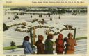
| Description: | Five people are standing at a fence rail looking down at King's Gateway Hotel. Caption reads: "Winter View at King's Gateway Hotel from the Top of the Ski ... |
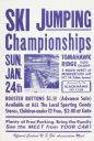
| Date: | 01 1971 |
|---|---|
| Description: | Poster for the Tomahawk Ridge Ski Jumping Championships, held Sunday, January 24, 1971. An official Central U.S. Ski Association Meet, sponsored by the Bl... |

| Date: | 1948 |
|---|---|
| Description: | Holiday card of a trainload of skiers with their skis on their way to the slopes. |

| Date: | 1942 |
|---|---|
| Description: | Holiday card with an Army soldier skiing down a hill. He is wearing a backpack and holding a piece of paper with the message "Merry Xmas" on it. Mountains ... |
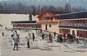
| Date: | |
|---|---|
| Description: | Color postcard of the Chalet at Mt. Telemark. Skiers and skis are in front of the Chalet. |
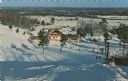
| Date: | |
|---|---|
| Description: | Color postcard of an elevated view of the Chalet at Mt. Telemark and surrounding area, and many skiers and several ski lifts. |
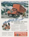
| Date: | 10 1947 |
|---|---|
| Description: | Advertising proof for International trucks, featuring a color illustration of a Model KBR-11 truck-tractor with semi-trailer. Includes the text: "Winter Tr... |

| Date: | 1970 |
|---|---|
| Description: | This map is intended for tourists of La Crosse. The cover features images of farms and natural land and reads: "friends are but strangers... we have yet to... |

| Date: | 1969 |
|---|---|
| Description: | This map shows ski areas, resorts, camps, special areas, airports, and roads. The map covers Vilas and Oneida counties and parts of Iron, Price, Lincoln, L... |

| Date: | 2006 |
|---|---|
| Description: | This map includes indexed advertisements and map of the Lac du Flambeau region on back. The map is broken into 9 zones, each marked with state and club tra... |

| Date: | 1962 |
|---|---|
| Description: | This map shows roads, golf courses, ski areas, boat landings, camp sites, waysides, parks, beaches, scenic views, virgin timber tracts, airports, boys and ... |

| Date: | 1960 |
|---|---|
| Description: | This pictorial map shows recreation activities, rivers, lakes, and the history of the area. The map covers Langlade County and parts of adjacent counties. ... |

| Date: | 1987 |
|---|---|
| Description: | This map shows federal highways, state or county highways, rivers, lakes, town roads, township boundaries, county boundaries, national or state forest, loo... |

| Date: | 1987 |
|---|---|
| Description: | This map shows county forests, state, federal, and interstate highways. County forests lands are shown in light green. The front of the map includes images... |

| Date: | 1966 |
|---|---|
| Description: | This colored road map shows automobile roads in Wisconsin as well as portions of nearby states. A map key indicates relative sizes of cities and towns. On ... |

| Date: | 1966 |
|---|---|
| Description: | This colored road map shows automobile roads in Wisconsin as well as portions of nearby states. Information on the quality and type of any road shown (inte... |

| Date: | 1972 |
|---|---|
| Description: | This colored map displays Wisconsin and bordering areas of Iowa, Minnesota, and Michigan. There is color-coding on the map to indicate National Forests, an... |

| Date: | 1970 |
|---|---|
| Description: | This colored map displays detailed maps of Green Bay, Appleton, Racine, Milwaukee, Kenosha, and Duluth-Superior. At the top right is a map location list of... |

| Date: | 1971 |
|---|---|
| Description: | This colored map displays Wisconsin and bordering areas of Iowa, Minnesota, and Michigan. There is color-coding on the map to indicate National Forests, an... |

| Date: | 1973 |
|---|---|
| Description: | This colored map displays Wisconsin and bordering areas of Iowa, Minnesota, and Michigan. There is color-coding on the map to indicate National Forests, a... |
If you didn't find the material you searched for, our Library Reference Staff can help.
Call our reference desk at 608-264-6535 or email us at: