 Filter: Categories of Wisconsin Historical Images
Filter: FORMAT_TYPE of prints, photomechanical
Filter: Subject of human settlements
Filter: Categories of Wisconsin Historical Images
Filter: FORMAT_TYPE of prints, photomechanical
Filter: Subject of human settlements
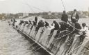
| Date: | 1910 |
|---|---|
| Description: | Long row of men in suits and hats fishing on the breakwater. |
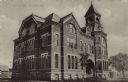
| Date: | |
|---|---|
| Description: | Exterior view from street towards the high school. A date stone above a second floor window reads: "Erected A.D. 1887." |

| Date: | 1924 |
|---|---|
| Description: | Unexecuted design by Frank Lloyd Wright of Nakoma Country Club, for which the architect received a fee of $5,000. |

| Date: | |
|---|---|
| Description: | View of the businesses on Union Street, notably J.P. Dennett's Drug Store, located on the far right corner. |
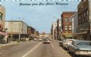
| Date: | 1961 |
|---|---|
| Description: | View down street of the downtown business district, including Woolworth's (left side) and Actor's Rexall Drug Store (right side). Caption reads: "Greetings... |
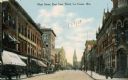
| Date: | 1910 |
|---|---|
| Description: | Main Street looking eastwards from Third Street. E.M. Young's Drugstore is in the lower left hand corner. Caption reads: "Main Street, East from Third, La ... |

| Date: | 1876 |
|---|---|
| Description: | Bird's-eye view of Black Earth. |

| Date: | 1867 |
|---|---|
| Description: | Birds-eye drawing of Appleton, Outagamie Co., depicting street names and street layout, houses, the Fox River, the court house, jail, school houses, Lawren... |

| Date: | 1910 |
|---|---|
| Description: | Map of Dane County rural delivery in Madison and the town of Westport. |

| Date: | 1836 |
|---|---|
| Description: | Map of all Dane County and eastern towns. |

| Date: | 1839 |
|---|---|
| Description: | This map shows the hydrology of Madison and its vicinity at the height of interest in a proposed Milwaukee and Rock River Canal. It was made by Thomas Jeff... |

| Date: | 1916 |
|---|---|
| Description: | Map of all automobile roads out of Madison, compliments of the Madison Board Of Commerce. |

| Date: | 1910 |
|---|---|
| Description: | Map of the general plan of the district of the Four Lakes. |
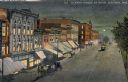
| Date: | 1910 |
|---|---|
| Description: | Elevated view at night of streetcars moving along the Capitol Square on Pinckney Street. Walzinger's Drugstore is one of the prominent storefronts on the l... |

| Date: | 04 01 1932 |
|---|---|
| Description: | A schedule of Transamerican Airlines covering its service to Chicago, Detroit, Cleveland, and other Great Lakes cities. The unfolded schedule depicts two p... |
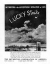
| Date: | 1923 |
|---|---|
| Description: | Advertisement for Lucky Strike cigarettes that shows the product name being written as a smoke trail above New York City. The campaign was devised for the... |
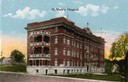
| Date: | 1915 |
|---|---|
| Description: | St. Mary's Hospital soon after its completion in 1911. Caption reads: "St. Mary's Hospital." |
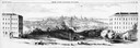
| Date: | 1858 |
|---|---|
| Description: | Panoramic sketch of State Street between North and South Halls on the University of Wisconsin-Madison campus. Published in Frank Leslie's Illustrate Newsp... |
| Date: | 1910 |
|---|---|
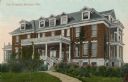
| Description: | View of City Hospital, which became known as Madison General Hospital and is now Meriter Hospital. It was designed by Madison architects Louis W. Claude an... |
| Date: | 1915 |
|---|---|
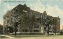
| Description: | Central High School, designed by St. Paul architect Cass Gilbert and partially razed in 1986. Caption reads: "High School, Madison, Wis." |
If you didn't find the material you searched for, our Library Reference Staff can help.
Call our reference desk at 608-264-6535 or email us at: