Filter: Categories of Wisconsin Historical Images
Filter: FORMAT_TYPE of prints, photomechanical
Filter: Subject of ferries
Filter: Categories of Wisconsin Historical Images
Filter: FORMAT_TYPE of prints, photomechanical
Filter: Subject of ferries
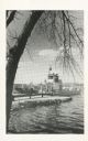
| Date: | 1910 |
|---|---|
| Description: | Elevated view across water toward the Larks Hotel and ferry. Caption reads: "Larks Hotel, Wisconsin Dells." |
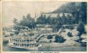
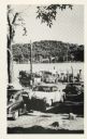
| Date: | |
|---|---|
| Description: | View across water towards a large ferry docked at the fishing wharf. A large group of people are standing on the pier, and passengers are standing at the r... |
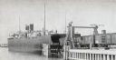
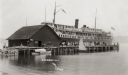
| Date: | 1899 |
|---|---|
| Description: | Chicago, St. Paul, Minneapolis & Omaha train cars loading onto car ferry Pere Marquette. |
| Date: | |
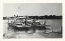
|---|---|
| Description: | The Merrimac ferry loaded with automobiles. There is an American flag flying on the ferry. |
| Date: | |
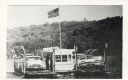
|---|---|
| Description: | The Merrimac ferry "Colsac" with an American flag. |
| Date: | |
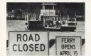
|---|---|
| Description: | The Merrimac ferry "Colsac II" is seen on the Wisconsin River behind two signs. The signs read, "Road Closed" and "Ferry Opens April 15". |
| Date: | |
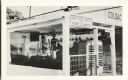
|---|---|
| Description: | A close view of the Merrimac ferry "Colsac I" with a sign reading, "Stop Your Motor When Ferry Is Moving". |
| Date: | |
|---|---|
| Description: | Automobiles line up to wait for the Merrimac ferry "Colsac". |

| Date: | |
|---|---|
| Description: | A view of the Brownrich ferry carrying a horse and wagon. |
| Date: | |
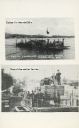
|---|---|
| Description: | Two images of ferries as printed on a postcard. The top image is the ferry "Colsac" on the Wisconsin River. The bottom image is simply described as an earl... |

| Date: | 1862 |
|---|---|
| Description: | This detailed map shows batteries and rifle pits, railroads, common and military roads, turnpikes, city streets and names, bridges, ferries, rural houses a... |

| Date: | 1939 |
|---|---|
| Description: | This nine-part map from the U.S. Bureau of Public Roads identifies federal and state highways in Wisconsin by pavement type. County, forest, park, and publ... |

| Date: | 1944 |
|---|---|
| Description: | This nine-part map from the U.S. Bureau of Public Roads identifies federal and state highways in Wisconsin by pavement type. County, forest, park, and publ... |

| Date: | 1950 |
|---|---|
| Description: | This road map shows federal, state and county roads in Wisconsin, northern Illinois, northeastern Iowa, eastern Minnesota, and the western portion of Michi... |

| Date: | 1940 |
|---|---|
| Description: | This tourist map of Door County, Wisconsin, lists the points of interest and tourist hotels, cabins and cottages in the area. Ferry schedules to Washington... |

| Date: | |
|---|---|
| Description: | Color postcard of view across water towards the "Nichevo II" ferry for Bayfield-Madeline Island moving through the water and filled with tourists and their... |

| Date: | 1911 |
|---|---|
| Description: | This map of Duluth and Superior shows street car routes, railroads, ferries, some points of interest, and lighthouses. The bottom left of the map reads: "C... |

| Date: | 05 01 1899 |
|---|---|
| Description: | Map showing the Schuylkill River with roads, ferries, and points of interest from Valley Forge to Philadelphia, Pennsylvania as it appeared during the Revo... |

| Date: | 1966 |
|---|---|
| Description: | A colored map depiction of Door County, Wisconsin, with pictorial highlights, titled: "Door County — Wisconsin's Air Conditioned Peninsula Playground." |
If you didn't find the material you searched for, our Library Reference Staff can help.
Call our reference desk at 608-264-6535 or email us at: