 Filter: Categories of Wisconsin Historical Images
Filter: FORMAT_TYPE of prints, photomechanical
Filter: Subject of cities and towns
Filter: County of Vilas
Filter: Categories of Wisconsin Historical Images
Filter: FORMAT_TYPE of prints, photomechanical
Filter: Subject of cities and towns
Filter: County of Vilas
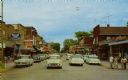
| Date: | 1958 |
|---|---|
| Description: | View down center of street in downtown Eagle River, with traffic, pedestrians, and automobiles parked along the curb. There are storefronts and signs on bo... |
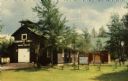
| Date: | 08 22 1964 |
|---|---|
| Description: | Colorized postcard of the Community Church with many trees surrounding it. |
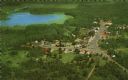
| Date: | 1959 |
|---|---|
| Description: | Color postcard of an aerial view of town. There is a lake in the background in the upper left. |
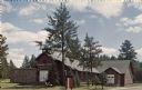
| Date: | |
|---|---|
| Description: | Color postcard of the Community Church with many trees surrounding it. |

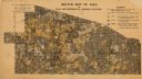
| Date: | 1926 |
|---|---|
| Description: | This Wisconsin Conservation Commission map from the 1920s shows roads, railroads, campsites, lookout towers, and privately owned lands in Northern Forest S... |

| Date: | 1933 |
|---|---|
| Description: | This 1933 Wisconsin Conservation Dept. map shows roads, railroads, trails, lakes and streams, and the Trout Lake Game Refuge in Northern State Forest (whic... |

| Date: | 1908 |
|---|---|
| Description: | This 1908 map shows the town and range grid, sections, cities and villages, acreages, settlers, schools, wagon roads, railroads, saw mills, and lakes, stre... |

| Date: | 1914 |
|---|---|
| Description: | This 1914 map shows the soil types in Vilas County, Wisconsin, and adjoining areas in Oneida, Forest, and Iron counties. Also depicted are the township and... |
| Date: | 1920 |
|---|---|
| Description: | This early 20th century map shows the soil types in Vilas County, Wisconsin, and adjoining areas in Oneida, Forest, Iron, and Price counties. Also depicted... |

| Date: | 1936 |
|---|---|
| Description: | These two maps of the Town of Conover, Vilas County, Wisconsin, show private land holdings of a section or more as of 1927 and public lands in 1936. Acreag... |

| Date: | |
|---|---|
| Description: | This map of Vilas County, Wisconsin, from the first half of the 20th century, shows the township and range grid, towns, sections, cities and villages, road... |

| Date: | 1933 |
|---|---|
| Description: | This mid-20th century map shows the township and range grid, towns, sections, cities and villages, roads, railroads, and lakes and streams in Vilas County,... |

| Date: | 1952 |
|---|---|
| Description: | This Wisconsin Conservation Dept. map shows sections, roads, rivers, and lakes in the Town of Cloverland, Vilas County, Wisconsin as of February, 1952. It ... |

| Date: | 1952 |
|---|---|
| Description: | This Wisconsin Conservation Dept. map shows sections, roads, rivers, and lakes in the Town of Presque Isle, Vilas County, Wisconsin as of March 1953. It do... |

| Date: | 1956 |
|---|---|
| Description: | This 1956 map shows sections, cities and villages, roads, railroads, and lakes and streams in the Eagle River area. All or part of the towns of Plum Lake, ... |

| Date: | 1940 |
|---|---|
| Description: | Map shows hydrography and location of game fish in part of Vilas County, Wisconsin and Gogebic County, Michigan. |

| Date: | 1909 |
|---|---|
| Description: | This 1909 map of northern Wisconsin and a portion of Michigan's Upper Peninsula shows the Lac du Flambeau Indian Reservation, cities and villages, railroad... |

| Date: | 1953 |
|---|---|
| Description: | This mid 20th century map of Vilas County and northeastern Oneida County, Wisconsin, shows the township and range grid, sections, cities and villages, rail... |
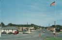
| Date: | 1968 |
|---|---|
| Description: | Elevated view of the main business district. Cars are parked in front of businesses, and are driving down the road. A flagpole and stop signs are in the fo... |
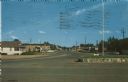
| Date: | 1966 |
|---|---|
| Description: | View of the commercial district. Cars are parked in front of businesses. A flagpole and a stop sign are on a highway island in the foreground. |
If you didn't find the material you searched for, our Library Reference Staff can help.
Call our reference desk at 608-264-6535 or email us at: