Filter: Categories of Wisconsin Historical Images
Filter: FORMAT_TYPE of prints, photomechanical
Filter: Subject of cities and towns
Filter: County of Juneau
Filter: Categories of Wisconsin Historical Images
Filter: FORMAT_TYPE of prints, photomechanical
Filter: Subject of cities and towns
Filter: County of Juneau
| Date: | 1905 |
|---|---|
| Description: | Unpaved road in downtown Camp Douglas. There is a bluff in the background on the right. Caption reads: "Camp Douglas, Wisconsin." |
| Date: | 1908 |
|---|---|
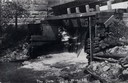
| Description: | View from shoreline toward the lower part of a dam. Caption reads: "Dam in Elroy, Wis." |
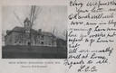
| Date: | 1900 |
|---|---|
| Description: | Exterior view of high school buildings with trees. Caption reads: "High School Buildings, Elroy, Wis." |

| Date: | 1900 |
|---|---|
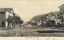
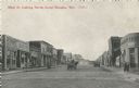
| Description: | View down street with businesses and storefronts on both sides. Caption reads: "Center Street, Wonewoc, Wis." |
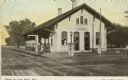
| Date: | 1910 |
|---|---|
| Description: | View across street and railroad tracks toward the railroad depot in Lone Rock. A man is standing on the platform. Caption reads: "Depot at Lone Rock, Wis." |

| Date: | 1905 |
|---|---|
| Description: | View down tree-lined sidewalk, with Division Street on the right. Caption reads: "Division St. Looking South, Mauston, Wis." |

| Date: | 1905 |
|---|---|
| Description: | View down wide, unpaved street with businesses and storefronts on both sides. Caption reads: "State Street, Mauston, Wis." |

| Date: | 1905 |
|---|---|
| Description: | View down wide, unpaved street with businesses and storefronts on both sides. Captions read: "Mauston, Wis." and "State Street." |

| Date: | 1905 |
|---|---|
| Description: | Elevated view of State Street. There is a parade coming down the street, and crowds are on the sidewalks. Caption reads: "State Street, Looking East, Maust... |

| Date: | 1905 |
|---|---|
| Description: | View across fields toward the town. Caption reads: "Birdseye[sic] view of Mauston, Wis." |

| Date: | |
|---|---|
| Description: | View across intersection towards storefronts on the left. On the corner is the Post Office, and further down are signs for the "Exide Battery Station," and... |
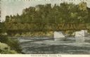
| Date: | 1905 |
|---|---|
| Description: | Petenwell Bridge. Caption reads: "Pete-eu-nell Bridge, Necedah, Wis." |

| Date: | |
|---|---|
| Description: | Etching of East Lemonweir Lutheran Church. Etching from a centennial souvenir dated July, 1954. People are walking up the stairs to the church entrance. Ca... |

| Date: | 1950 |
|---|---|
| Description: | Aerial view of the Highway 21 bridge and Petenwell Dam on the Wisconsin River. |

| Date: | 1926 |
|---|---|
| Description: | This hand-colored blueprint map shows landowners in part of T15N, R5E in Juneau County. North is oriented to the right. |

| Date: | |
|---|---|
| Description: | Colorized postcard of Main Street. On the left is E.J. Anthony, Barber, with a barber pole in front of the building. Other businesses can be seen, many wit... |
| Date: | 1912 |
|---|---|
| Description: | Colorized postcard of "The Ruins." A brick hotel (possibly the MLAKAR HOTEL) is behind and to the right of the old foundation. Various signs are pasted on ... |
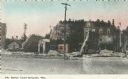
| Date: | 1911 |
|---|---|
| Description: | Black and white postcard of Main Street, looking north. A horse-drawn wagon is traveling north and another is parked on the right. On the left is a store, ... |
If you didn't find the material you searched for, our Library Reference Staff can help.
Call our reference desk at 608-264-6535 or email us at: