 Filter: Categories of Wisconsin Historical Images
Filter: FORMAT_TYPE of prints, photomechanical
Filter: Subject of capitols
Filter: Categories of Wisconsin Historical Images
Filter: FORMAT_TYPE of prints, photomechanical
Filter: Subject of capitols

| Date: | 1920 |
|---|---|
| Description: | A map of Madison and the vicinity. Red lines show the street railway. |

| Date: | 1890 |
|---|---|
| Description: | Portion of a plat map of Madison featuring Lake Mendota. |
| Date: | |
|---|---|
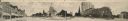
| Description: | Panoramic view of Capitol Square, seen from the West corner. Originally functioned as an oversized post card. Identifiable businesses include Haswell Furni... |
| Date: | |
|---|---|
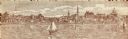
| Description: | Panoramic view of Capitol Square, seen from the South corner. Originally functioned as an oversized post card. Ringling Brothers Circus advertisement visib... |
| Date: | 1870 |
|---|---|
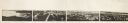
| Description: | Panoramic view of Madison, taken from the roof of South Hall. This reduced copy was made from original negatives by E.C. Nielson. Labels for both Lake Mend... |

| Date: | 1835 |
|---|---|
| Description: | Map reads: "Map of the United States of America with its Territories and Districts - Including also a part of Upper and Lower Canada and Mexico". The map i... |
| Date: | 1900 |
|---|---|
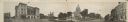
| Description: | A view of the city of Madison circa 1900 that was used as a letterhead. |

| Date: | 1889 |
|---|---|
| Description: | Ticket for the inauguration of President Benjamin Harrison. This ticket belonged to William Freeman Vilas of Wisconsin, the Secretary of the Interior. The ... |
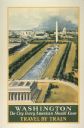
| Date: | 1934 |
|---|---|
| Description: | An original lithograph promoting Washington, D.C. as "the city that every American should know," and to get there by way of train travel. The poster depict... |
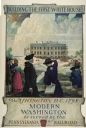
| Date: | 1932 |
|---|---|
| Description: | An original lithograph promoting Washington, D.C., and the Pennsylvania Railroad through artist N.C. Wyeth's depiction of the 1798 construction of the firs... |
| Date: | 1860 |
|---|---|
| Description: | Miss Columbia is standing on the body of a fallen soldier. She has a sword in her right hand and is holding the Union flag in her left hand. The words: "TH... |

| Date: | 1937 |
|---|---|
| Description: | A man wearing a hat and tie is driving an International I-12 industrial tractor with mower attachment to groom the grounds in front of the Arkansas state c... |

| Date: | 1839 |
|---|---|
| Description: | A chart showing the geological cross-section and the height above the surrounding landscape of several locations, such as Platte Mound in Wisconsin, and th... |

| Date: | 1853 |
|---|---|
| Description: | Wisconsin counties by color and shows railroads, common roads, canals, the state capital, county towns, townships, villages, and post offices, |

| Date: | 1854 |
|---|---|
| Description: | Map of the whole state Wisconsin includes an inset of the vicinity of Milwaukee, which shows the boundaries for Lisbon, Menomonee, Pewaukee, Brookfield, Wa... |

| Date: | 1792 |
|---|---|
| Description: | Map of Washington D.C. Labeled on the map are all the main streets, the site of the Capitol and the President's House. The map also shows the relationship ... |
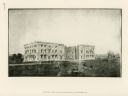
| Date: | 1814 |
|---|---|
| Description: | Exterior view of the U.S. Capitol building after the fire in August. The Federal building was burned by British forces during the War of 1812. In the foreg... |
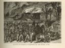
| Date: | 1814 |
|---|---|
| Description: | Etching depicting the burning of Washington, D.C. by the British during the War of 1812. In the foreground are a number of soldiers moving toward the Capit... |
If you didn't find the material you searched for, our Library Reference Staff can help.
Call our reference desk at 608-264-6535 or email us at:

