 Filter: Categories of Wisconsin Historical Images
Filter: FORMAT_TYPE of prints, photomechanical
Filter: Subject of botany
Filter: Subject of business
Filter: Categories of Wisconsin Historical Images
Filter: FORMAT_TYPE of prints, photomechanical
Filter: Subject of botany
Filter: Subject of business

| Date: | 1861 |
|---|---|
| Description: | Shows townships and sections, landowners, and woodlands. Includes inset maps of Monroe, Brodhead, Albany, Cadiz, Decatur, Dayton, Clarence, Springfield, Tw... |

| Date: | 1858 |
|---|---|
| Description: | This map is hand-colored and mounted on cloth and shows lot and block numbers and dimensions, landownership, streets, railroads, selected buildings, fair g... |

| Date: | 1980 |
|---|---|
| Description: | This map shows the locations of 42 businesses, roads, points of interest, recreation sites, camping, the North Country Trail and parking, and boundaries of... |
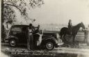
| Date: | 1944 |
|---|---|
| Description: | A man in an overcoat is leaning against a parked car, with a man in overalls standing next to him. A sign in the car window reads: "Your stock needs Occo M... |
If you didn't find the material you searched for, our Library Reference Staff can help.
Call our reference desk at 608-264-6535 or email us at: