 Filter: Categories of Wisconsin Historical Images
Filter: FORMAT_TYPE of prints, photomechanical
Filter: Reproduction Rights of For Sale
Filter: Categories of Wisconsin Historical Images
Filter: FORMAT_TYPE of prints, photomechanical
Filter: Reproduction Rights of For Sale
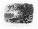
| Date: | 1832 |
|---|---|
| Description: | Travellers setting up camp along the Missouri River. |
| Date: | 1832 |
|---|---|
| Description: | Mih-Tutta-Hangkusch, a Mandan village with boats on the river in foreground. |

| Date: | 1832 |
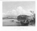
|---|---|
| Description: | Junction of the Yellowstone River and the Missouri River. |

| Date: | 1891 |
|---|---|
| Description: | Bird's-eye map of Wausau, looking north with ninety-eight businesses, industries, churches, schools, and civic buildings identified in location key below i... |
| Date: | 1949 |
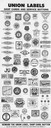
|---|---|
| Description: | Union Label Trades Department poster with samples of shop cards and union buttons from various trades. Created by Amalgamated Meat Cutters & Butcher Work... |

| Date: | 03 1892 |
|---|---|
| Description: | Detail map including West Washington Avenue, West Main Street, West Wilson Street, and North and South Bedford Streets. Includes the Chicago, Milwaukee & S... |
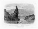
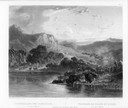
| Date: | 1832 |
|---|---|
| Description: | The Citadel Rock on the Upper Missouri River. |
| Date: | 1832 |
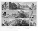
|---|---|
| Description: | Remarkable hills on the Upper Missouri River (views 1-9). Various landscapes and rock formations. |
| Date: | 1832 |
|---|---|
| Description: | Herds of bison and elk on the Upper Missouri River. |

| Date: | 1853 |
|---|---|
| Description: | Bird's-eye map of Milwaukee looking east toward Lake Michigan from a bluff, long since graded into a slope, at about 6th Street between Wisconsin Avenue an... |

| Date: | 1885 |
|---|---|
| Description: | Bird's-eye view of Watertown with indexed points of interest. |

| Date: | 1862 |
|---|---|
| Description: | Drawn the second year of the Civil War, this 1862 map of Milwaukee shows post offices, light houses, beacon lights, county buildings, elevator warehouses, ... |
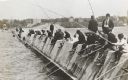
| Date: | 1910 |
|---|---|
| Description: | Long row of men in suits and hats fishing on the breakwater. |
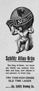
| Date: | |
|---|---|
| Description: | Advertisement for Schlitz Atlas-Brau with Atlas carrying the earth with a Schlitz label on his shoulders. Some text reads, "Ask for Schlitz. The Beer That ... |
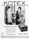
| Date: | |
|---|---|
| Description: | A Kotex feminine product advertisement from early in the 20th century. |

| Date: | 1917 |
|---|---|
| Description: | Color lithograph illustration of a McCormick header taken from an International Harvester General Line Catalog. Includes the text: "grand prize winner at S... |
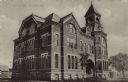
| Date: | |
|---|---|
| Description: | Exterior view from street towards the high school. A date stone above a second floor window reads: "Erected A.D. 1887." |
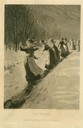
| Date: | 1880 |
|---|---|
| Description: | Engraving for "Peterson's Magazine" of women in maids' uniforms sliding down an icy path in the snow. |

| Date: | 1924 |
|---|---|
| Description: | Unexecuted design by Frank Lloyd Wright of Nakoma Country Club, for which the architect received a fee of $5,000. |

| Date: | |
|---|---|
| Description: | View of the businesses on Union Street, notably J.P. Dennett's Drug Store, located on the far right corner. |
If you didn't find the material you searched for, our Library Reference Staff can help.
Call our reference desk at 608-264-6535 or email us at: