 Filter: Categories of Wisconsin Historical Images
Filter: FORMAT_TYPE of prints, photomechanical
Filter: Reproduction Rights of For Sale
Filter: Subject of railroad bridges
Filter: Categories of Wisconsin Historical Images
Filter: FORMAT_TYPE of prints, photomechanical
Filter: Reproduction Rights of For Sale
Filter: Subject of railroad bridges

| Date: | 1896 |
|---|---|
| Description: | Bird's-eye map of Darlington. Area bordered by Washington and North Streets, upper left hand corner, the fairgrounds, upper right corner, River Street, bot... |

| Date: | 1877 |
|---|---|
| Description: | Bird's-eye map of Janesville on the Rock River. |

| Date: | 1870 |
|---|---|
| Description: | Bird's-eye map of Kilbourn City, now known as Wisconsin Dells. Kilbourn City was platted in the 1850s and received a boost when the La Crosse and Milwaukee... |

| Date: | 1883 |
|---|---|
| Description: | Bird's-eye map of Prairie du Sac, Wisconsin with an inset of Clifton. |

| Date: | 1883 |
|---|---|
| Description: | Bird's-eye map of Sauk City. |

| Date: | 1891 |
|---|---|
| Description: | Bird's-eye map of Stevens Point, looking east, with an inset of the Water Works. Wisconsin River in foreground with fifty-three business locations identifi... |

| Date: | 1879 |
|---|---|
| Description: | Bird's-eye map of Two Rivers. |
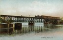
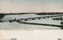
| Date: | |
|---|---|
| Description: | The railroad bridge over the Rock River. |
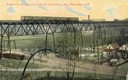
| Date: | 1911 |
|---|---|
| Description: | Elevated view across valley toward a streetcar viaduct on the Waukesha Interurban Line, near Milwaukee. Caption reads: "Street Car Bridge on Waukesha Inter... |
| Date: | 1905 |
|---|---|
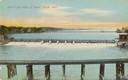
| Description: | Fox River with a view of Appleton in the background. Caption reads: "Water Power, Appleton, Wis." |
| Date: | 1905 |
|---|---|
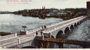
| Description: | Elevated view of John Street Bridge. Caption reads: "John Street Bridge, Appleton, Wis. Largest stone arch bridge in Wisconsin." A railroad bridge runs acr... |
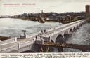
| Date: | 1906 |
|---|---|
| Description: | Elevated view of the bridge, which is intersected by a railroad bridge. Caption reads: "John St. Bridge, Appleton, Wis. Largest stone arch bridge in Wiscon... |
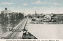
| Date: | 1905 |
|---|---|
| Description: | Elevated view of the river, with railroad tracks on the left shoreline, and a railroad bridge crossing the river. Caption reads: "View of River from Grand ... |
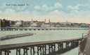
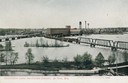
| Date: | 1905 |
|---|---|
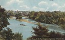
| Description: | View of the Rock River with the Northwestern Railroad Bridge in the foreground and Beloit in the background. Caption reads: "Bird's-Eye View of River, Belo... |
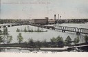
| Date: | 1905 |
|---|---|
| Description: | Elevated view of the Rock River. Caption reads: "Rock River, N.W. Ry. Bridge, and glimpse of Beloit, Wis." |
| Date: | 1906 |
|---|---|
| Description: | Caption reads: "Panoramic View of Fox River, De Pere, Wis." Elevated view of the bridge crossing over the Fox River near De Pere. |
| Date: | 1915 |
|---|---|
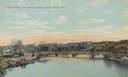
| Description: | Elevated view of government locks and factory district on the Fox River. Caption reads: "Government Locks and Factory District, De Pere, Wis." |
| Date: | 1906 |
|---|---|
| Description: | Elevated view. Caption reads: "Government Locks & Factory District, De Pere, Wis." |
| Date: | 1910 |
|---|---|
| Description: | Elevated view of the Northwestern Manufacturing Company plant. Caption reads: "Birds-eye View showing Northwestern Mfg. Co.'s Plant, Fort Atkinson, Wis." |
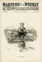
| Date: | 07 14 1894 |
|---|---|
| Description: | Cartoon depicting "King Debs" a man wearing a crown representing Debs American Railway Union, sitting atop the highway of trade. |
If you didn't find the material you searched for, our Library Reference Staff can help.
Call our reference desk at 608-264-6535 or email us at: