 Filter: Categories of Wisconsin Historical Images
Filter: FORMAT_TYPE of prints, photomechanical
Filter: Reproduction Rights of For Sale
Filter: Community of Trempealeau
Filter: Categories of Wisconsin Historical Images
Filter: FORMAT_TYPE of prints, photomechanical
Filter: Reproduction Rights of For Sale
Filter: Community of Trempealeau

| Date: | 1931 |
|---|---|
| Description: | Drawing of the Melchoir House, which was a popular hostelry and brewery operated by Jacob Melchoir. It later became an Indian boarding house. |

| Date: | 1854 |
|---|---|
| Description: | This map is mounted on cloth and shows lot and block numbers, streets, additions, and public squares. Also included is information on Trempealeau, an inset... |

| Date: | 1920 |
|---|---|
| Description: | This blue print map shows landownership between 1913 and 1916, topography, railroads, and roads. The map covers the vicinity of Perrot State Park. |

| Date: | 01 28 1862 |
|---|---|
| Description: | Letterhead depicting a scene in the Battle of Big Bethel, in which Lieutenant John T. Greble refused to pull back, as he continued to fire his last cannon.... |
| Date: | 1936 |
|---|---|
| Description: | Text on front reads: "Trempealeau Wis. on the Great River Road overlooking Lock & Dam No. 6 on the Upper Mississippi." On reverse: "Lock & Dam No. 6, one o... |

| Date: | 1950 |
|---|---|
| Description: | Text on front reads: "Main Street - Trempealeau, Wisconsin." On reverse: "On the Grand Old Mississippi and the Great River Road near Perrot State Park and ... |

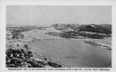
| Date: | 1920 |
|---|---|
| Description: | Text on front reads: "Trempealeau, Wis., on-the-Mississippi." Aerial view of the town on the Mississippi River. |

| Date: | 09 04 1913 |
|---|---|
| Description: | Text on front reads: "'Castle Rock,' 2nd Peak, Trempealeau, Wis., on-the-Mississippi." Elevated view towards a rock formation on the Mississippi River. Isl... |
If you didn't find the material you searched for, our Library Reference Staff can help.
Call our reference desk at 608-264-6535 or email us at: