 Filter: Categories of Wisconsin Historical Images
Filter: FORMAT_TYPE of prints, photomechanical
Filter: Reproduction Rights of For Sale
Filter: Community of Green Bay
Filter: Categories of Wisconsin Historical Images
Filter: FORMAT_TYPE of prints, photomechanical
Filter: Reproduction Rights of For Sale
Filter: Community of Green Bay

| Date: | |
|---|---|
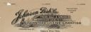
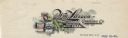
| Description: | Letterhead of the Gazette Publishing Company, a printer and publisher of the "Green Bay Gazette" newspaper, with the name of the company in undulating type... |
| Date: | |
|---|---|
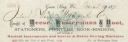
| Description: | Billhead of Neese, Kustermann & Root of Green Bay, Wisconsin, stationers, printers, book-binders, and dealers in musical instruments and sewing machines. T... |

| Date: | |
|---|---|
| Description: | Memohead of the Green Bay Transportation Company, with a center image of a steamer traveling on the water and a life preserver on one side printed with the... |
| Date: | |
|---|---|
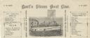
| Description: | Letterhead of Hart's Steam Boat Line of Green Bay, Wisconsin, with a steam boat named after the proprietor, C.W. Moore, with a flag bearing the same name. ... |

| Date: | 1934 |
|---|---|
| Description: | Label submitted to the state of Wisconsin for trademark registration. Old Imperial Pale, made by the Rahr-Green Bay Brewing Corporation. The label also inc... |
| Date: | 1842 |
|---|---|
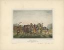
| Description: | Menominee war dance, as depicted by Francois, Comte de Castelnau, a French naturalist and diplomat who visited Green Bay, Wisconsin about 1838. This detail... |

| Date: | 01 25 1944 |
|---|---|
| Description: | Label submitted to the State of Wisconsin for trademark registration. Label for canned food from the Larsen Company. Features a can of corn, with fresh ear... |
| Date: | |
|---|---|
| Description: | Memohead of the Johnson Fish Company of Green Bay, Wisconsin, wholesalers of "fresh. salt. & smoked fish, oysters and live crawfish," with a fish being pul... |
| Date: | |
|---|---|
| Description: | Letterhead of the Wm. Larsen Canning Company of Green Bay, Wisconsin, with peapods growing on the vine and three cans of peas: Larsen's Special Brand, Gree... |

| Date: | 1816 |
|---|---|
| Description: | This is a photostat copy of a manuscript map in the National Archives showing a plan of Fort Howard and a view of its north side. Originally surveyed by Wi... |

| Date: | 1914 |
|---|---|
| Description: | This map is a photostat copy from the original 1829 map in the War Department. The map shows location of Fort Howard, lots, land claims of Jacques Porlier ... |

| Date: | 1868 |
|---|---|
| Description: | Map showing the northern water routes between Mississippi River and Atlantic Ocean Relief shown by hachures. Includes Profile of the Erie Canal, table of ... |

| Date: | 08 27 1825 |
|---|---|
| Description: | Map is ink on paper. Map shows plat of the town of Munnomunne, the Fox River, farm lots, and an established highway. The map is signed by "J.D. Doty, Propr... |

| Date: | 1836 |
|---|---|
| Description: | This map of Navarino shows a development plat of the village situated opposite Fort Howard at mouth of the Fox River. The names of proprietors are listed a... |

| Date: | 1900 |
|---|---|
| Description: | This map of Green Bay shows plat of the town, lots by number, local streets, the military Fort Howard, part of Fox River and part of Navarino. The map feat... |

| Date: | 1974 |
|---|---|
| Description: | This map shows roads, highways, railroads, major arterials, towns, parks, recreational areas, and parts of Fox River and bay of Green Bay. The map includes... |

| Date: | 1856 |
|---|---|
| Description: | This map shows a plat of town, local streets, and parts of East and Fox Rivers. |

| Date: | 1868 |
|---|---|
| Description: | This map shows land ownership by name, lots, roads, railroads, and part of the Fox River. The map includes an explanation and table of witnesses to the cor... |

| Date: | 1930 |
|---|---|
| Description: | This map shows a plat of the town, local streets, railroads, creeks, part of Fox River, and part of the bay of Green Bay. The location of the original fort... |
| Date: | 1930 |
|---|---|
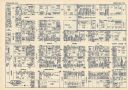
| Description: | This map shows local streets, blocks, lots, local businesses by name, and bus stops. On the back of the map is text, illustrations, and aerial views. |
If you didn't find the material you searched for, our Library Reference Staff can help.
Call our reference desk at 608-264-6535 or email us at: