 Filter: Categories of Wisconsin Historical Images
Filter: FORMAT_TYPE of prints, photomechanical
Filter: County of Waukesha
Filter: Categories of Wisconsin Historical Images
Filter: FORMAT_TYPE of prints, photomechanical
Filter: County of Waukesha

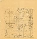
| Date: | 1873 |
|---|---|
| Description: | Plat map of the township of Eagle (T5N, R17E) at a scale of 2 inches to one mile. |

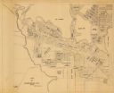
| Date: | 1846 |
|---|---|
| Description: | This map of Prairieville, later renamed Waukesha, is ink and pencil on paper and shows the Fox River, a plat of village, and lot owners. |

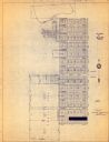
| Date: | 1871 |
|---|---|
| Description: | This map of Waukesha shows lot owners, buildings, and various plat additions. The margins of the maps include street reference, a Waukesha business directo... |

| Date: | 1962 |
|---|---|
| Description: | This map shows the voting districts of Waukesha in red ink for the year 1962. The bottom of the map includes an index of streets. |
| Date: | 1925 |
|---|---|
| Description: | This map shows township sections, roads, railroads, and lakes. The map also features extensive manuscript annotations noting landownership in pencil. Stamp... |
| Date: | 1950 |
|---|---|
| Description: | This map is revised by McMahon Engineering Company, Menasha, Wisconsin and shows plat of town, local streets, concrete monument, iron stake, government sto... |

| Date: | 1965 |
|---|---|
| Description: | This basic street map shows roads, schools, parks and cemeteries and includes a street index in the lower margin. The map also shows a portion of Elm Grove... |
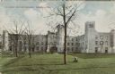
| Date: | 1910 |
|---|---|
| Description: | Colored postcard view of a large building and grounds at St. John's Military Academy. Caption reads: "St. John's Military Academy, Delafield, Wis." |
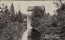
| Date: | 1910 |
|---|---|
| Description: | Black and white photographic postcard view of an old mill and stream. Caption reads: "The Old Mill at Delafield, Wis." |
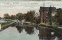
| Date: | 1910 |
|---|---|
| Description: | Colored postcard view of the old mill, stream and a dam. Caption reads: "Old Mill and Race, Near Milwaukee, Wis. At Delafield." |
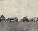
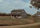
| Date: | |
|---|---|
| Description: | View of barn, house, and outbuildings at Keystone Farms, owned by Owen W. Rolands. |

| Date: | 1904 |
|---|---|
| Description: | A young Alfred Lunt dressed as Rip Van Winkle, using clothing and a musket borrowed from farm hands and leggings made of gunny sacks. |

| Date: | 1910 |
|---|---|
| Description: | Aerial view of the Wisconsin Masonic Home and Farm on Highway 18, thirty miles west of Milwaukee. |
| Date: | 1910 |
|---|---|
| Description: | Artist's rendering of Jericho Street, showing storefronts. There is a metal railing between the sidewalk and the street. Caption reads: "Jericho Str. Eagle... |

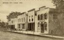
| Date: | 1920 |
|---|---|
| Description: | View down center of unpaved street, showing storefronts on the right, with a metal railing between the street and sidewalk. There is a gas pump at the rail... |
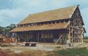
| Date: | 1970 |
|---|---|
| Description: | Color photographic postcard of the Koepsel house being reassembled at Old World Wisconsin near Eagle. It is an 1860's half-timber farmhouse that was built ... |
| Date: | 1950 |
|---|---|
| Description: | Color photographic postcard of the Turck-Schottler house at Old World Wisconsin near Eagle. It is an 1875 German blockbau building tradition that is listed... |
| Date: | |
|---|---|
| Description: | This map is a photocopy and shows the Oconomowoc River, Flower Lake, lot and block numbers and dimensions, additions, streets, C.M.St.P.&P. Ry., T.M.E.R.&L... |

| Date: | 1970 |
|---|---|
| Description: | This map shows lots, house numbers, institutional buildings, and cemeteries. The bottom of the map includes indexes to streets, points of interest and inst... |

| Date: | 1965 |
|---|---|
| Description: | This map shows wards, schools and public buildings, and polling places. The map includes a street index. Lac La Belle, Fowler Lake, and Oconomowoc Lake are... |
If you didn't find the material you searched for, our Library Reference Staff can help.
Call our reference desk at 608-264-6535 or email us at: